
(UPDATE: Sept. 12 @ 6:15 pm) – The White Rock Lake continues to be classified as held.
The small portion of the fire above the Banks Creek drainage area has not burned down to the control line yet, so BC Wildfire Service (BCWS) crews continue to monitor and patrol the area.
Today, there are 92 firefighters, nine pieces of heavy equipment, four danger tree fallers and three helicopters on scene.
According to today’s BCWS update, thermal imaging is being used to identify hotspots within 100 feet of the fire perimeter and will continue to be extinguished.
Yesterday, on the eastern flank along Westside Road, crews engaged in small-scale hand ignitions to burn small areas of unburned fuel near the control line above Fintry.
BCWS confirms that “full extinguishment of this control line should be complete by Sept. 14.”
On the north, north east and west flanks, crews are demobilizing equipment, establishing hoses and performing mop up activities.
Although the agency had to reclassify the fire back to being held this weekend and smoke will continue to be visible, it is confirmed that “there is no threat of further spread.”
(UPDATE: Sept. 11 @ 5:30 pm) – Although the White Rock Lake wildfire has received sufficient suppression action to ensure no further spread, the fire has been reclassified as being held.
BC Wildfire Service (BCWS) explains that the reclassification is “due to prevailing and forecasted seasonably dry Okanagan conditions.”
No growth has been observed and the agency still estimates that the fire burned approximately 83,342 hectares.
There are 95 firefighters, nine pieces of heavy equipment, five helicopters and four danger tree fallers on site today.
According to this morning’s update, a flank above the Banks Creek drainage area has not burned down to the control line yet.
“This section of the fire will continue to burn freely and put up smoke until it reaches the control lines where crews can safely extinguish the fires edge,” adds BCWS.
However, all other perimeters of the fire are being monitored and patrolled while all hotspots within 100 feet of the edge are being extinguished by ground crews.
The agency confirms that smoke will be visible from stumps and roots within the secured perimeter, however, there is no threat of further spread.
(UPDATE: Sept. 9 @ 10:40 am) – The White Rock Lake wildfire "continues to burn deep underground," the BC Wildfire Service has explained.
The blaze, which is now under control, is burning beneath surface level because of severe drought, the agency added.
"Given the extent and intensity of this wildfire, residual hot spots and smoke well within the fire's perimeter will continue to be highly visible over the coming weeks," BCWS said.
"All perimeters of the fire continue to be actively monitored or patrolled by wildfire management staff."
The agency said it is using thermal imaging technology to identify hot spots so crews can extinguish them.
"Smoking stumps and roots within the secured fire perimeter pose no risk of fire spread and will continue to burn into the winter," BCWS said.
"Although smoke will continue to be visible, there is no threat of further spread."
The evacuation order issued for the seasonal properties on Bouleau Lake and Pinaus Lake by the Regional District of North Okanagan due to the fire, meanwhile, has been rescinded.
All RDNO Electoral Area properties that were affected by the fire have now been given the all-clear.
(UPDATE: Sept. 7 @ 2:30 pm) – The Regional District of Central Okanagan has rescinded the remaining evacuations alerts for 1,316 properties on Bouleau Lake Road and the Estamont, Ewings Landing, Killiney Beach and Westshore Estates.
The State of Local Emergency, which has been in place since July 30, has also been rescinded.
The White Rock Lake wildfire is now classified as under control.
“Our hearts go out to the North Westside communities as they begin the road to recovery from the longest wildfire-related evacuation in our regional district’s history,” says Regional District of Central Okanagan chair Gail Given.
According to the Regional District, the only Local State of Emergency that lasted longer was due to the floods in 2017.
“We know what a trying and emotional summer this has been for property owners, and we will work with them and the various service providers, provincial ministries, utilities and other agencies in the days and weeks ahead to restore the community,” adds Given.
Now, North Westside Road residents begin the long journey to recovery.
Starting today, Central Okanagan residents whose homes had significant structural damage can contact the Regional District's Recovery Office at 250-469-6111 or email [email protected].
Killiney Water System customers have access to a self-serve water filling station at the corner of Westside and Firwood Roads.
Residents who have damaged fridges or freezer can call 1-855-238-9350 to schedule a pickup.
Homeowners who require extra help with clean up can contact Samaritan’s Purse, which is set up at Vernon Alliance Church, at 1-866-628-6565.
Residents who have animals in the care of ALERT can call 250-809-7152 or CDART 250-809-9589.
(UPDATE: Sept. 7 @ 11:33 am) – More properties have been given the all-clear in response to the taming of the White Rock Lake wildfire.
The Columbia-Shuswap Regional District has rescinded its evacuation alerts for the following areas:
More information can be found here.
(UPDATE: Sept. 7 @ 5:21 am) – The White Rock Lake wildfire's status has been upgraded to "under control."
It was previously "being held."
BC Wildfire Service explained: "The wildfire has received sufficient suppression action to ensure no further spread of the fire."
The is estimated to be 83,342 hectares in size.
An area restriction remains in place.
"Objectives will remain fairly static over the next week(s) as most of the fire is in patrol status," BCWS said.
It added: "Division Bravo (east flank): Action hotspots above cherry orchard by Sept. 8. Complete extinguishment of Fintry guard by Sept. 14. Continue mop up along Bear Road. Gear retrieval and demob.
"Division Charlie (northeast flank, south of Glenemma): Complete mop-up of Irish Creek excursion and guard by Sept. 7. Monitor Ewer Creek control lines on both sides of the valley. Gear retrieval and demob.
"Division Yankee (north flank): Extinguish all scanned hotspots in perimeter north of Highway 97 and in western perimeter south of Highway 97 by Sept 7. 100-foot patrol along southeastern perimeter toward Div Charlie by Sept. 10. Action visible hotpots along road networks and property lines in Paxton Valley. Gear retrieval and demob.
"Division Zulu (west flank): Complete hotspotting from latest scan data and mop up along Div Z perimeter by Sept. 8. 100-foot patrol on east division towards Div Alpha by Sept. 8th. Gear retrieval and demob.
"Division Alpha (south flank): Aerial resources continue to monitor this flank of the fire."
(UPDATE: Sept. 6 @ 2:30 pm) – The Regional District of Central Okanagan has rescinded the evacuation order for 18 properties on Bouleau Lake Road.
According to the agency’s website, 2,166 properties remain on evacuation alert.
Visit cordemergency.ca to view the detailed map.
“While we are thankful that we can finally welcome all residents back to their homes, this is just the start of the recovery process” says Corie Griffiths, regional EOC director.
“Many hazards exist within the area on both public and private lands and residents need to be careful re-entering their properties to start the cleanup.”
Westside Road remains open to local traffic only.
Killiney Water System customers remain on a “do not consume” notice but can access a self-serve water filling station at the corner of Westside Road and Firwood Road.
There have been no changes to the evacuation alerts issued by the Regional District of North Okanagan.
Evacuation notices issued by the Columbia Shuswap Regional District also remain unchanged at this time.
Visit the Thompson-Nicola Regional District website for more information on rescinded evacuation orders and alerts issued on Wednesday, Sept. 1.
There are 218 firefighters, 26 pieces of heavy equipment, 19 structure protection personnel. Six danger tree fallers and five helicopters on site today.
Crews continue to patrol and extinguish hotspots across all flanks of this wildfire.
Although it is classified as being held the fire remains an active work site and residents are reminded by BC Wildfire Service to respect the area restriction.
(UPDATE: Sept. 4 @ 11:30 am) – More evacuation notices are being downgraded as BC Wildfire Crews continue to patrol and mop up the White Rock Lake wildfire.
The fire remains classified as held after it burned an estimated 83,342 hectares.
On Thursday, Sept. 2, the Regional District of North Okanagan (RDNO) partially rescinded an evacuation order for properties on the west side of Irish Creek Road.
Twenty properties on the west side of Irish Creek Road have been downgraded to an evacuation alert while properties in electoral area “B” remain on evacuation order at this time.
On Friday, Sept. 3, the RDNO downgraded an evacuation order for properties on Six Mile Creek Road and Siwash Road.
The Central Okanagan Emergency Operations also removed evacuation alerts for properties from Caesars Landing to Fintry (West electoral area).
Eighteen properties on the Bouleau Lake Road remain on evacuation order.
As of Friday, 2,259 properties from Estamont, Ewings Landing, Killiney Beach and Westshore Estates remain on evacuation alert.
Visit cordemergency.ca to view a detailed map.
The Okanagan Indian Band partially rescinded an evacuation order on Friday as well.
The affected properties include:
Evacuation order for all addresses south of the Mudhole Road to the southern area of IR 1, including Whiteman’s Creek, Lawrence Beach, Parker Cove.
Evacuation order remains in place for all addresses within Mini-Shadows Road.
Evacuation alert remains in place for ALL properties west of Hwy 97 and south of Irish Creek Rd and ALL addresses south of Goodwater Dr. to Mudhole Road.
Evacuation alert has been rescinded for all properties east of Hwy 97 and along the east side of Okanagan Lake.
There are 246 firefighters, 26 pieces of heavy equipment, 19 structure protection personnel, six danger tree fallers and five helicopters still working on the White Rock Lake wildfire.
Crews on the eastern flank will move into patrol status by Sunday, Sept. 5.
On the northeast flank, crews will complete their goal of containment and continue with a mop up of 100 feet within the fire’s perimeter.
Crews on the northern and western flank will continue to extinguish hotspots and mop up in their areas.
Aerial resources continue to monitor the southern flank.
(UPDATE: Sept. 3 @ 4:23 pm) - As the White Rock Lake wildfire has been determined as being held by BCWS, crews are patrolling for hot spots and working on mop up efforts for the area.
On the east flank, Division Bravo will be happening until Sept. 5 to extinguish hotspots found by the scan 100ft into the perimeter and near structures.
On the northeast flank south of Glenemma, Division Charlie will be completing containment and mop of excursion on the Irish Creek North Flank by Sept. 5. A burn plan may be implemented only if needed, and mop ups to 100ft within the perimeter along Ewer Creek will be completed by Sept. 8.
On the north flank, Division Yankee will extinguish all scanned hotspots north of Hwy 97 and western perimeters south of Hwy 97 by Sept 7.
On the west flank, Division Zulu will complete hotspotting from scan data and mop up on: Tiger Road to Monte Pratt by Sept. 7, Douglas Lake Rd to Monte Pratt by Sept. 7, Hwy 97B to Torch Rd by Sept. 7, and Douglas Lake FSR to helipad 5 by Sept. 8. As well as work on recovery and return of gear to the warehouse.
On the south flank, Division Alpha is responding with aerial resources to monitor this side of the fire.
There are currently 281 wildland firefighters, 26 pieces of heavy equipment, 19 structure protection personnel, seven danger tree assessors/fallers, five helicopters, and a BC Wildfire Service Incident Management Team and additional support staff on scene.
(UPDATE: Sept. 2 @ 6:00 pm) - BCWS has just announced that the White Rock Lake wildfire is now considered held at 83,342 hectares.
Over the last 52 days, BCWS and provincial, First Nation, national, and international partner agencies have maintained response efforts on the White Rock Lake wildfire.
"The wildfire is not likely to spread beyond determined containment lines due to the suppression carried out by the BC Wildfire Service," said BCWS.
At the fire's peak, the fire camp in Vernon housed over 500 people directly engaged in wildfire response.
A considerable amount of work remains to be done to completely suppress the fire, but firefighters will stay engaged until there is no risk of impact to public health, critical infrastructure, property, or environmental, economic and social values.
BC Wildfire Service provided a statement thanking "The commitment of heavy equipment operators, helicopter pilots, camp kitchen operators, facility managers, incident support staff, security staff, among countless others, to keep firefighters supported on the ground."
Due to significant effort from the #BCWildfire Service and provincial, First Nation, national and international partner agencies, the White Rock Lake wildfire (K61884) is now considered ‘Being Held’. pic.twitter.com/AvEQBNTizp
— BC Wildfire Service (@BCGovFireInfo) September 3, 2021
(UPDATE: Sept. 2 @ 4:30pm) - Many people along Westside Road have been displaced from their homes for weeks by the White Rock Lake wildfire, but many neighbourhoods have just recently received the approval to return home.
In consultation with BCWS, CORDE, and the Ministry of Transportation and Infrastructure evacuation orders have been rescinded and downgraded to evacuation alerts.
The neighbourhoods of Ewings Landing, Killiney Beach, and Westshore Estates will finally be able to re-enter the area.
Residents must enter from the south along Westside Road as the north end of the road remains closed until further notice, no access will be permitted from the north to any properties in RDCO.
Non-residents should avoid using Westside Road between Firwood Rd and Irish Creek Rd in order to manage traffic flow. There is also no access to Parker Cove.
People returning to West Shore Estates are asked to consider postponing their return until after 5 pm.
A Do Not Consume Water notice has been put in place for the Killiney water system which affects more than 280 properties. The water should not be used for drinking, brushing teeth, or food preparation.
Residents are being told to bring home bottled water as boiling the water will not make it safe.
White Rock Lake Evacuation Orders Rescinded https://t.co/LWrVQXdbuO
— Central Ok Emergency (@CO_Emerg) September 2, 2021
Killiney is also under stage four water restrictions, which means no outdoor water use except what is required for health and safety.
In addition, a Water Quality Advisory is in place until further notice for the Upper Fintry-Shalal Road-Valley of the Sun water systems.
An evacuation order remains in place for 18 properties on Bouleau Lake Road and there is no public access to the Bouleau Lake area. The Everly Recreation Site remains closed to the public.
The RDNO has also rescinded a portion of its evacuation order to an alert for the westside of Irish Creek Road within Electoral Area ‘B’. This includes 20 properties on the west side of Irish Creek Road and Beatrice Road that are not within the Okanagan Indian Band IR#1.
The evacuation order for the remaining properties in Electoral Area ‘B’ located on the west side of Okanagan Lake remains in effect.
(UPDATE: Sept. 2 @ 9:18 am) – All evacuated North Westside residents are expected to be able to return home by the weekend, Central Okanagan Emergency Operations (CORD) has said.
The announcement comes as Valley of the Sun residents head back home after an evacuation order covering properties in the subdivision was downgraded to an alert on Wednesday.
“We are close to bringing people safely home thanks to the hard work of firefighters of the North Westside Fire Rescue and the men and women from the fire departments from around the province,” said North Westside Fire Chief Alex Van Bruksvoort.
“It’s almost time to turn the corner, we’re almost there – and we appreciate everyone’s patience during this trying time.”
The BC Ministry of Transportation and Infrastructure has assessed hazards on Westside Road between Shalal and Firwood Roads, CORD explained.
Residents re-entering the area must enter from the south along Westside Road.
Traffic control will be in place to ensure that only local traffic enters into the new alert area, CORD added.
Westside Road, meanwhile, will remain closed from Firwood to Irish Creek Roads until further assessments and mitigation work can be completed.
The Rapid Damage Assessment Team completed its assessment of properties affected by the White Rock Lake wildfire late on Wednesday, CORD said.
The agency added: "Returning residents are reminded that they may encounter some remaining hazards on their properties."
A CORD video session on returning home is available to view here.
"While recent cooler temperatures and precipitation have supported fire suppression efforts, the White Rock Lake wildfire continues to be active and is classified as out of control by BC Wildfire," CORD explained.
Area residents and property owners whose buildings suffered significant structural damage will be able to access resources at rdco.com/recovery, email [email protected] or call 250-469-6111.
BC Wildfire Service still estimates the fire to be about 83,112 hectares in size.
(UPDATE: Sept. 1 @ 4 pm) – The City of Vernon has rescinded its evacuation alert that was issued due to the White Rock Lake wildlife.
The City explains that the current and forecasted weather and site conditions influenced the decision to rescind the evacuation alert.
(as of Sept 1/21 @ 1pm)
— City of Vernon (@CityofVernon) September 1, 2021
The City of Vernon has rescinded the Evacuation Alert for the following areas (see map below):
•Canadian Lakeview Estates
•Adventure Bay
•Tronson Road between 8125 and 9280
Read the full release here: https://t.co/gg3vXrBxJd pic.twitter.com/dF1ddQBHLU
“We know there is still a lot of work to be done in areas that remain under Evacuation Order and there has been great loss experienced within neighbouring communities,” said Vernon mayor Victor Cumming.
“Our hearts go out to each of you and we offer sincere condolences.”
The Township of Spallumcheen rescinded the last portion of its evacuation alert today as well.
The Okanagan Regional District also rescinded an evacuation order for the Valley of Sun subdivision, they remain on evacuation alert.
Those properties include:
All other evacuation orders and alert remain in effect, visit cordemergency.ca for more information.
The Columbia Shuswap Regional District has not changed any evacuation alerts at this time.
The evacuation order issued by the Regional District of North Okanagan remains in effect.
An evacuation alert was rescinded to all clear for 435 Thompson-Nicola Regional District properties on Aug. 18.
The Okanagan Indian Band rescinded an evacuation order for addresses listed in this link, an evacuation alert remains in effect.
(UPDATE: Sept. 1 @ 11:20 am) - BC Wildfire Service has released more information about this week's successful planned burn at the White Rock Lake wildfire.
The ignition in Irish Creek covered 975 hectares, bringing the fire's estimated size up to 83,112 hectares.
BCWS said its crews brought the fire down to established control lines in several key areas on the northeast of the blaze's perimeter.
That makes containment possible in the next nine days, the agency added.
"The burn plan objectives were to mimic natural wildfire with up to 30 per cent tree mortality and understory woody debris consumption," BCWS said in a post on social media accompanied by a video of the burn.
"The Irish Creek area has over 40 years of woody debris buildup. Areas that had significant fuel build up, combined with very steep slopes, burned with more intensity.
"This resulted in a patchwork burn with pockets of more intense fire behaviour that is seen when natural wildfire moves through a forest.
"Ground crews used hand ignitions to bring the fire down to six kilometres of guard along the northeast perimeter."
The agency added: "Out of the 975 hectares, 14 hectares of fire burned across containment lines in a 920-metre stretch along the guard when decked logs ignited by more intense fire behaviour.
"A unit crew managed this excursion with full containment achieved the next morning on Aug. 31."
The video posted by BCWS was filmed by crewmember Billy Stevens.
(UPDATE: Sept. 1 @ 7 am) - No growth was observed at the White Rock Lake wildfire on Tuesday, BC Wildfire Service has confirmed.
Firefighters continue to benefit from cooler and wetter weather as well as a successful planned burn that helped secure control lines.
Central Okanagan Emergency Operations, meanwhile, said last night that damage assessors inspected hundreds of homes as work to lift the evacuation order on the North Westside progresses.
“Our Rapid Damage Assessment Team is focusing on neighbourhoods known to have fire damaged homes and more than 250 homes have been inspected and the team anticipates completing their work Thursday,” said CORD Director Corie Griffiths.
“We strongly encourage people to attend our Returning Home Information Session on what to expect when they can ultimately return home.”
The information session is geared towards Central Okanagan West Electoral Area residents who have been evacuated as a result of the White Rock Lake wildfire and will be livestreamed today between 4 and 5 pm here.
The fire remains out of control at 81,362 hectares.
BCWS said last night it had 345 firefighters, 52 structure protection specialists, seven helicopters, 38 pieces of heavy equipment and various auxiliary personnel at the fire.
(UPDATE: Aug. 31 @ 9:36 am) - Evacuated North Westside residents have been asked to extend their patience a little longer as firefighters work to ensure their homes are safe in the wake of the disastrous White Rock Lake wildfire.
The blaze remains out of control at 81,362 hectares – but BC Wildfire Service said last night it could be contained as soon as next week.
BCWS, the Regional District of Central Okanagan and others are assessing risks to properties in the evacuation areas, Central Okanagan Emergency Operations (CORD) said.
That means watching out for spot fires, tree hazards and loose ground.
The risk assessments are required before a decision can be made on any evacuation order downgrades.
There are 1,316 properties still under order in the area, with 850 on alert. So far 78 properties have been significantly damaged in the fire.
CORD explained: "By mid-week, it is anticipated that residents will be provided with a Return Home Guide and be invited to attend a Return Home Information Session. More details on this information session will be provided as soon as they are confirmed."
The BC Ministry of Transportation and Infrastructure, meanwhile, continues to assess the safety and condition of Westside Road and conduct necessary mitigation work.
Westside Road remains closed for more than 31 kilometres between Shalal and Irish Creek Roads until further notice.
“This is a hard time for all the residents of the North Westside community, which includes the firefighters. North Westside Fire Rescue crews are working daily on extinguishing the wildfire, alongside with all agencies, day and night to bring an end to the evacuation order,” said North Westside Fire Chief Alex Van Bruksvoort.
“I ask daily for your patience, and today is no different as we get closer to bringing the residents home. Patience is our strength, and listening to wrong information weakens all of us.”
In its latest update, BCWS said it had 345 firefighters at the scene.
They are being supported by 52 structure protection sepcialists, seven helicopters, 38 pieces of heavy equipment and various auxiliary staff.
(UPDATE: Aug. 31 @ 5:33 am) - The planned burns at the White Rock Lake wildfire have been completed, BC Wildfire Service said.
The burning will continue in the area for the next several days, the agency explained, producing smoke.
Crews and aircraft will continue to patrol the area, which BCWS said on Monday was about 3,000 hectares.
"These ignitions have brought the fire down to established control lines in several key areas on the northeast of the fire," BCWS said.
"This has reduced the risk of further growth and impacts in the interface area, which is the area of the fire that poses a risk to structures."
BCWS also said that securing the northeast of the fire means the agency can recommend that evacuation orders and alerts are downgraded "much sooner."
"Containment may now be achieved in the next 7-10 days versus upwards of six weeks if the fire was left to naturally reach containment lines," BCWS said.
Corie Griffiths, regional director at Central Okanagan Emergency Operations, said: “We understand that residents are anxious to know when they can get back into their communities.
“But there is a lot of work that needs to be done across multiple agencies to ensure that these areas are safe before residents return.”
BCWS added: "Significant groundwork and planning occurred over the past two weeks in order to conduct a successful planned ignition.
"The Thunderbirds Unit Crew, Rangers Unit Crew and RAP India worked tirelessly to build a large fuel-free area to support ignitions today."
The fire is still classed as out of control at 81,362 hectares.
(UPDATE: Aug. 30 @ 4:10 pm) - The large planned burn taking place on the White Rock Lake wildfire is more than halfway done, the BC Wildfire Service has confirmed.
A large plume of smoke has been noticeable from surrounding areas since the process started earlier today and increased smoke is expected to continue into the evening.
The burn is happening on the north end of Okanagan Lake.
The BCWS said that planned ignition operations like this one are critical to achieve containment in areas where the fire perimeter is inoperable and unsafe for ground crews and heavy equipment to work.
"Planned ignitions are the safest way to remove fuel that can burn well into fall and winter by the wildfire," the agency explained.
"In 2018, fires that occurred in severe drought areas burned underground over winter and started burning in the spring again."
Today's large-scale ignition in the Irish Creek Road area is critical to ensure that the fire perimeter is secure as possible with no fuel available for further growth.
(UPDATE: Aug. 30 @ 10:52 am) – The BC Wildfire Service has released a video explaining the reasoning behind this morning's large planned burn at the White Rock Lake wildfire.
BCWS said the 3,000-hectare burn, between Six Mile Creek and Irish Creek Road, was expected to begin as early as 9:30 am this morning.
Operations Chief Andre Chalabi said it was crucial to execute the burn to protect both residents and firefighters.
Chalabi said the fire "still has the potential" to spread towards communities, meaning a planned ignition is "the best option."
Also this morning, North Westside Fire Chief Alex Van Bruksvoort said spoke of the high levels tension among residents near the fire.
“I was reminded tonight of how frayed all our nerves are in regards to the wildfires,” he said.
“I received multiple calls today and tonight about the fires burning above Valley of the Sun. North Westside Fire Rescue was there standing by as BC Wildfire did controlled ignitions.
"We did this to ease the fears of all the residents and the Firefighters. Please be patient as all this is being done to safeguard your neighbourhoods on the North Westside.”
Central Okanagan Emergency Operations also said this morning that it is "mobilizing all available resources" to get evacuated residents back to their homes as soon as possible.
But the agency added: "However, this is expected to be a long process and the patience of residents is appreciated."
“Assessments are underway for all the properties on evacuation order and we are trying determine which areas can return safely,” said Corie Griffiths, regional EOC director.
“BC Wildfire Service continues to do planned ignitions in some areas to remove debris and fuel from the area and utilities assessment work is underway.”
(UPDATE: Aug. 30 @ 5:58 am) – The large planned burn in the Irish Creek Road area of the White Rock Lake wildfire that was announced last week is expected to finally go ahead today.
BC Wildfire Service said the ignition, which will cover about 3,000 hectares of land, will be "low intensity" with a "low tree mortality."
"Planned ignition operations are critical to achieve containment in areas where the fire perimeter is inoperable and unsafe for ground crews and heavy equipment to work," the agency explained.
"Planned ignitions are the safest way to remove fuel that can burn well into fall and winter by the wildfire. In 2018, fires that occurred in severe drought areas burned underground over winter and started burning in the spring again."
The ignition is necessary because of the "extreme drought" in the area, BCWS said.
It is "critical" to execute the burn so the fire's perimeter can be secured.
"Without these ignitions, the wildfire will continue to burn out of control into fall in heavy fuels with the potential to impact Hwy 97 and the surrounding interface," BCWS explained.
The agency added: "The ignitions will occur in three phases and are further broken down into three sections. First, a heli-torch machine is used to build heat and create a column within the burn area. This draws the main ignition up and into the column well within established control lines.
"Second, a Plastic Sphere Dispenser will be used to conduct the main ignition in each section to manage fire intensity and utilize terrain to draw fire into the column.
"Third, ground crews will ignite from control lines using drip torches to bring fire right to the guards in a controlled manner."
The fire remains at an estimated 81,362 hectares and is still out of control.
“Ground crews are working with BC Wildfire to identify hotspots and deal with hazards,” Corie Griffiths, regional director of Central Okanagan Emergency Operations Centre.
“I know many are anxious to return home and there is a coordinated effort underway to restore utilities, identify hazards and move towards making things safe for the public in order for some residents to return to their neighbourhoods.”
The evacuation order for 1,316 properties and 850 properties on alert in the North Westside communities within the Regional District of the Central Okanagan remains unchanged.
Residents can visit cordemergency.ca/map to determine if their property is on order or alert.
“We appreciate the partnership with BC Wildfire throughout the past month as our community faced this unprecedented fire,” added Griffiths.
“We have now been given the ability from BC Wildfire Incident Command to do our work as an early step to get you back into your homes as soon as safely possible. We are in very early stages and there is much to be done.”
To date 78 properties have been confirmed as having sustained significant damage.
(UPDATE: Aug. 29 @ 12:15 pm) – There was no significant growth on the White Rock Lake wildfire overnight and it remains at 81,362 hectares.
Today there are 369 firefighters, 57 structure protection personnel, 40 pieces of heavy equipment, 14 helicopters, five danger tree fallers and an incident management team on site.
Sixty Canadian Armed Forces personnel joined the suppression effort on the western flank and another 60 are due to arrive later today to help on the northern flank.
The @CFOperations began their relocation from Oliver and 100 Mile to #Vernon today to assist #BCWildfire with response efforts on the White Rock Lake fire (K61884). Fellow motorists are requested to be patient and give space on the road while troops and equipment are relocated. pic.twitter.com/ylY5vO021N
— BC Wildfire Service (@BCGovFireInfo) August 27, 2021
In today’s BCWS update it was confirmed that the 3,500 hectare ignition in the area near the Irish Creek Road is planned for Monday, Aug. 30 – if conditions remain favourable overnight.
The agency notes the devastating 2018 fire season and explains that fires burning in severe drought areas were burning underground over the winter and resurfaced the following spring.
Given that this part of the Thompson-Okanagan has been experiencing drought, the planned ignition is critical for crews to gain some degree of control over the fire.
According to BCWS, a large fire guard has been constructed over the past two weeks to prepare for the large-scale ignition.
Infrared scanning operations will be ongoing to identify hotspots so crews can continue to patrol and mop up the area.
There has been good progress made along the eastern flank and once these operations are completed, BCWS will reassess the area.
If the area is deemed safe again, BCWS can make recommendations regarding changes to current evacuation orders and alerts.
BCWS finished this morning’s update by noting that objectives will remain fairly static in the coming days as crews patrol and mop up.
Central Okanagan emergency operations confirms that the evacuation order for 1,316 properties and alert for 850 properties in the North Westside communities remains in effect.
“RCMP are doing patrols on the water, and in all areas of North Westside to help ensure people are staying out of the area as we continue our fire suppression efforts and put out hotspots.” says fire chief Alex Van Bruksvoort.
(UPDATE: Aug. 28 @ 2:30 pm) – The White Rock Lake wildfire was more accurately mapped at 81,362 hectares.
There are 281 firefighters, 92 structure protection personnel, 40 pieces of heavy equipment, 14 helicopters and seven danger tree assessors/fallers on site today.
There are 60 Canadian Armed Forces personnel arriving on site today – with another 60 arriving tomorrow.
According to BC Wildfire Service the size of the fire continues to require a large workforce to effectively patrol and mop up the entire fire perimeter.
At this time, there are no changes to the evacuation orders or alerts issued for residents in the North Westside communities within the RDCO.
“The men and women on the ground continue their dedicated work, including throughout the night, looking for and extinguishing hotspots,” notes fire chief Alex Van Bruksvoort.
“Thank you all for your patience as we work hard to safeguard the North Westside neighbourhoods so that residents can eventually return home.”
BCWS’s morning update explains that infrared drone scans will continue on the western, eastern and northern flanks.
The eastern flank, near the Fintry area, received approximately 5 millimetres of rain.
Rain was also received in the Six Mile Creek area but this makes conditions not favourable for the 3000 hectare planned ignition.
The BCWS update points out that “crews continue to see positive progress along all flanks of the fire.”
Crews on the eastern flank continue to mop up hotspots while the western flank is not showing any significant growth.
On the north flank crews are due to complete mop up along the Ingram FSR and north of Highway 97.
The southern flank is being monitored by aerial crews.
(UPDATE: Aug. 27 @ 9:45 am) – More good news from the front line in the battle against the White Rock Lake wildfire.
North Westside Fire Chief Alex Van Bruksvoort said crews are making progress against the fire's hotspots.
“Weather is cooperating with the efforts of BC Wildfire and amazing work is being done by several agencies,” Van Bruksvoort explained.
“Dangerous areas are persistent, but are being dealt with daily and North Westside Fire Rescue firefighters continue to do patrols."
But he added: "Please continue with your patience as we all work so hard to make your community safe for your return.”
The evacuation order for 1,316 properties and the alert covering 850 properties both remain in place.
BC Wildfire Service said the fire is now estimated to be 81,483 hectares.
The agency added: "Crews continue to see positive progress along all flanks of the fire.
"Danger tree assessments are currently being completed along the west flank of the fire in preparation for having military personnel commence patrolling in the area tomorrow."
There are 279 firefighters, 92 structure protection specialists, 14 helicopters, 45 pieces of heavy equipment and various support staff at the scene of the fire.
(UPDATE: Aug. 27 @ 6:00 am) – Firefighters continue to make "positive progress" across all areas of the White Rock Lake wildfire, BC Wildfire Service said late last night.
The agency is still waiting for the right weather to execute its 3,000-hectare planned burn, which firefighters had been hoping to begin as soon as Wednesday.
Winds on Thursday were "again not favourable," however, forcing BCWS to delay the burn once again.
Smaller burns were possible north of Terrace Mountain and west towards Shorts Creek on Wednesday.
BCWS said firefighters removed about 600 hectares of fuel between the fire's edge and the control line in that area.
In last night's update, BCWS said it expects to see increased fire behaviour along the northern ridge of Six Mile Creek because of an ongoing drought.
"Due to the steep and inaccessible terrain in this area of the fire, the larger-scale planned ignition operation remains the most favourable tactic to gain control while also maintaining an appropriate safety margin for firefighters," the agency said.
"If and when site conditions are favourable, additional information will be provided prior to ignition."
Structure protection personnel remained on-site overnight to patrol from Hwy 97 down Westside Road to Valley of the Sun, BCWS said.
The agency also said the firefighter who was injured at the blaze has now returned to the fire camp.
"The firefighter was working along a steep section of the control line when they lost their footing and took a tumble downhill," BCWS explained.
"Medical aid was on-site and responded accordingly."
The fire remains at 82,000 hectares and is classified as out of control.
(UPDATE: Aug. 26 @ 9:50 am) – Crews performed more planned ignitions on the White Rock Lake wildfire on Wednesday.
As a result of the 600-hectare burn, the fire is now estimated at 82,000 hectares in size.
"Crews continue to extinguish deep burning fuels that are persistent throughout the east flank of the fire as a result of severe drought conditions," explained the BC Wildfire Service.
"Crews are making good progress on mop-up and patrol activities along the south, west and northern flanks of the fire."
Wednesday's planned ignition focused on securing the perimeter of the fire on the southeast flank north of Terrace Mountain, removing hundreds of hectares of fuel between the fire's edge and pre-established control line.
On the east flank, patrol and mop-up continues throughout the Six Mile Creek valley bottom and an infrared scan this evening will help crews identify hot spots in the area.
An infrared scan has already been completed on the north flank of the fire, which helped personnel action hotspots within 50 feet of the fire perimeter.
No growth has been observed on the west flank of the fire over the past week and crews continue mop-up work in that area, while aerial resources continue to monitor the south flank of the fire.
A number of evacuation orders and alerts remain in place for this fire through a number of different regional districts and other local governments.
At this time, 295 wildland firefighters, 103 structure protection personnel, 44 pieces of heavy equipment, 14 helicopters, nine danger tree fallers and an incident management team with support staff are assigned to this fire.
(UPDATE: Aug. 25 @ 11:30 am): The White Rock Lake wildfire is now an estimated 81,300 hectares in size.
Most of the overnight growth came on the northeastern flank of the fire courtesy of Tuesday's planned ignitions.
The BC Wildfire Service will execute more planned ignitions today, starting around noon, to secure the fire perimeter north of Terrace Mountain and west above Shorts Creek.
"The planned ignitions, northwest of Fintry Park, aim to remove approximately 200 hectares of fuel along the fire’s edge and pre-established control line along the fire," explained a release from Central Okanagan Emergency Operations (CORD).
"During ignition operations, smoke will be visible in Kelowna, Lake Country, North Westside neighbourhoods, Okanagan Indian Band, Peachland, Vernon, Westbank First Nation, West Kelowna and other area communities."
These strategic burns are required to contain areas of the fire perimeter that are inoperable and unsafe for ground crews and heavy equipment to work, the BCWS explained.
Before planned ignitions take place, BCWS officials undergo advanced planning, forecasting and data analysis to ensure it's the appropriate move for that area.
It's been confirmed that this fire has directly impacted 78 properties to date and most Central Okanagan homeowners whose properties sustained significant structural damage have been contacted by CORD.
“As another day came to a close, I was quickly reminded of how volatile and quickly a wildfire can start and spread," said Alex Van Bruksvoort, North Westside fire chief.
"Both our neighbours had fires yesterday in the Bear Creek area and Okanagan Indian Band. I ask for your patience as we in here the North Westside still have an out of control fire above our community.”
There are currently 283 wildland firefighters, 102 structure protection personnel, 60 pieces of heavy equipment, 12 helicopters, nine danger tree fallers and a BCWS incident management team with support staff assigned to this fire.
(UPDATE: Aug. 25 @ 5:25 am) – Firefighters successfully executed a 350-hectare planned ignition north of Newport Beach on Tuesday, BC Wildfire Service said.
The agency said the "small-scale" burn was "critical" to securing the area east of a much bigger planned ignition set to go ahead sometime this week.
"This ignition burned at a relatively low intensity along the understory, with very little tree mortality," BCWS explained.
The agency said the larger burn will not be possible today because of strong winds.
Residents will be given warning before the burns go ahead, however.
A planned burn northwest of Fintry, meanwhile, is set to go ahead today.
BCWS said the ignition will remove about 200 hectares of dried-out fuel between the fire's edge and a five-kilometre machine guard south of the blaze.
The burn could go ahead as early as noon, the agency said.
"These ignition operations are critical to achieve more significant containment in areas of the fire perimeter that are inoperable and unsafe for ground crews and heavy equipment to work," BCWS said.
"Planned ignition operations work by removing unburned fuels from a constructed guard line. This limits the amount of fuels that could otherwise result in high intensity growth of the fire under forecasted weather conditions.
"Significant planning, forecasting, and data analysis has been completed and will continue to be assessed prior to the ignition operations occurring."
The fire remains out of control at 80,951 hectares.
(UPDATE: Aug. 24 @ 9:20 am) – The White Rock Lake wildfire has seen some growth and is now estimated at 80,951 hectares.
The fire has seen minimal growth over the past few days but as temperatures begin to rise BCWS is anticipating fire activity to increase.
There are 264 firefighters, 87 structural protection personnel, 56 pieces of heavy equipment, 13 danger fallers and 12 helicopters working on the fire today.
Crews working on the eastern flank of the fire continue to reinforce containment lines near communities and structures.
They are also preparing for the potential of an ignition operation on the southeast flank to remove unburned fuel between the guard and fire’s perimeter.
Today, the guard from Irish Creek to Six Mile Creek is due to be completed.
Crews in this area are also preparing for a potential ignition operation once conditions become favourable.
No growth has been observed on the northern flank of the fire above Highway 97 down to Woods Lake and mop up activities are ongoing.
The western flank continues to be patrolled and monitored due to a lack of activity.
BCWS notes that “a 52-kilometre contingency guard has been established south of the fire perimeter from Chapperon Lake moving eastward towards Fintry Park.”
Vernon remains on evacuation alert while the Township of Spallumcheen reduced the evacuation alert area yesterday afternoon.
The evacuation order for 1,316 properties and alert for 850 properties is unchanged for properties in the Central Okanagan Regional District.
Evacuation notices issued by the Columbia Shuswap, North Okanagan and Thompson-Nicola Regional Districts remain unchanged at this time.
Today, NowMedia staff will be taking part in the media tour of the Killiney Beach area.
Stay tuned for an update on that story.
(UPDATE: Aug. 23 @ 4:10 pm) – The Township of Spallumcheen has reduced the area that is under evacuation alert due to the White Rock Lake wildfire.
The statement explains that “cooler weather and precipitation in some areas has helped wildfire crews with their efforts, however, the [fire] remains close to the [Township’s] borders.”
Properties in the reduced evacuation alert include:
Visit spallumcheentwp.bc.ca for more details and any clarification.
Residents are reminded to monitor the website and the BC Wildfire Service website, should things change.
(UPDATE: Aug. 23 @ 12:13 pm) – A large-scale planned ignition could go ahead as soon as Wednesday along the northeastern flank of the White Rock Lake wildfire.
The timing, however, will depend on weather, according to the BC Wildfire Service.
The ignition will be over about 3,000 hectares, producing "significant" amounts of smoke that will be visible in Vernon, Falkland, Armstrong and elsewhere.
"Significant planning, forecasting, and data analysis has been completed and will continue to be assessed prior to the ignition operation," the agency explained.
BCWS said the ignition is necessary because the fire has spread into inaccessible terrain.
The safest way to gain control of the fire is therefore to burn away dried-out fuels between the control line and the advancing flames.
"Ground crews and hose lay will be ready to patrol and monitor for any spotting across the constructed machine guard between Westside Road and Irish Creek," BCWS explained.
If the weather changes "drastically," however, crews will reassess their options.
"However, at this time there is no alternative suppression tactic that will provide an equal or greater likelihood of success given the fuel type, terrain, and sustained drought conditions expected to persist over the coming weeks," BCWS explained.
The agency said the northeastern flank of the fire – near Vernon – is seeing extreme drought.
BCWS wildfire technician Scott Rennick said the northeastern flank is "by far" the most active part of the entire fire.
The White Rock Lake blaze is "basically two fires in one," Rennick explained, with the western side receiving much more rain – and even some hail.
The south of the fire has also been quiet, Rennick said, and not much growth is expected there over the next 10 days.
BCWS said it had 280 firefighters at the blaze, alongside 88 structure protection specialists, 10 helicopters, 55 pieces of heavy equipment and 11 tree specialists.
The fire remains out of control at 80,745 hectares.
(UPDATE: Aug. 23 @ 6:10 am) – The White Rock Lake wildfire remained calm last night as firefighters continue to benefit from cooler weather.
BC Wildfire Service said only minimal activity was observed on the north, west and south flanks of the blaze on Sunday.
"Strong winds were observed on the northeast flank throughout the day," the agency explained.
On Monday, BCWS said it is expecting a mainly cloudy day with the chance of thunderstorms in the afternoon.
Northwesterly winds gusting at up to 40 km/hr are also anticipated.
The fire was still estimated as 80,745 in BCWS's latest update.
(UPDATE: Aug. 22 @ 5:30 pm) – The White Rock Lake wildfire continues to show no growth this weekend.
There are 260 firefighters, 88 structure protection personnel, 55 pieces of heavy equipment, 11 helicopters and 11 danger tree fallers.
BCWS forecasts a mainly cloudy day with a high of 16ºC, scattered showers this afternoon and west/southwest winds of 10-15 km/h with gusts upwards to 40 km/h.
At this time, there have been no changes to any evacuation orders or alerts issued by:
In today’s Central Okanagan Emergency Operations (COEO) statement, North Westside Fire Rescue fire chief Alex Van Bruksvoort noted that BC Hydro was on site today to install new power infrastructure for the area.
COEO director Doug Gilchrist affirmed that the agency continues to support residents who may have lost their homes.
“Fire conditions permitting, we will be doing this by coordinating a site visit with these homeowners.”
Residents whose homes sustained damage were contacted directly and COEO explains that they understand the stress involved for the 1,316 properties on evacuation order and 850 properties on evacuation alert.
Due to the ongoing fire situation, not all areas affected by the fire have been assessed but it is expected that some homes may have water and smoke damage and restoration work may be needed.
Van Bruksvoort finished by saying, “We know residents want to return home, and we are doing all we can to ensure this can happen when it is safe to do so.”
Crews working on the eastern flank of the fire continue to attack hotspots and reinforce containment lines above the communities and properties in the area.
“Heavy equipment continues to work on re-establishing containment lines from the Terrace Mountain fire (2009) to tie into the guard at Stuart Lake.”
Fire guard construction is ongoing on the northeastern flank from Irish Creek to Six Mile Creek.
BCWS explains that no growth has been observed on the northern flank of the fire that is on the north side of Highway 97 down towards Woods Lake.
Crews in this area continue to build a guard to protect power lines in the area and towards Pinaus Lake.
The western and southern flanks continue to be monitored by air resources.
No growth has been observed on the western flank as crews begin constructing a contingency line near the Monte Creek area.
(UPDATE: Aug. 21 @ 11 am) – The White Rock Lake wildfire has been reassessed and is estimated to be burning at 80,745 hectares.
There are 244 firefighters, 88 structure protection personnel, 57 pieces of heavy equipment, 12 helicopters and 10 danger tree fallers on site today.
BCWS is forecasting a mainly cloudy day with a high of 21ºC, 40% humidity and light southern winds.
Some areas of the fire did receive rain this morning which has helped to reduce fire activity.
BCWS explains that, “suppression activities continue on all flanks of the fire with a focus along Westside Road where the wildfire has impacted communities.”
Although the Okanagan has been seeing lower temperatures, crews on this fire have observed an increase in fire activity on the northeast, east and southeast flanks.
This morning’s update explained that crews on the eastern flank have observed “incredibly deep burning forest fuels making it difficult to bring this area to full extinguishment.”
Structure protection personnel in this area are working to mop up hotspots around infrastructure that has been impacted by the fire.
Yesterday, on the northeast flank crews utilized planned ignitions to secure the containment line south of Irish Creek Road to west of Westside Road.
Mop up operations will continue today on the north flank.
BCWS reports no significant growth on the western flank of the fire while crews continue to mop up in the area.
On Aug.18, the Thompson-Nicola Regional District rescinded an evacuation alert to “all clear” for 435 properties in electoral areas “L” (Grasslands) and “M” (Beautiful-Nicola Valley-North).
All other notices remain in effect but be sure to visit tnrd.ca or the Facebook page for more information.
On Aug.18 the Columbia Shuswap Regional District partially rescinded an evacuation order for electoral area “D” (Cedar Hill).
The evacuation order issue issued on Aug. 15 by the Regional District of North Okanagan remains in effect.
At this time, there have been no changes to the evacuation notices issued by the Central Okanagan Regional District.
A few neighbourhoods in Vernon remain on evacuation alert.
There have been no changes to the evacuation alert for a portion of Spallumcheen or evacuation notices for the Okanagan Indian Band.
(UPDATE: Aug. 20 @ 10:47 am): Objectives for the White Rock Lake wildfire have been re-established as suppression efforts are now taking place on all flanks of the 81,139 hectare fire.
Warm weather is forecast for the Vernon area, with the potential of rain and thunderstorms developing in the coming days. The rain forecasted will help diminish fire activity for the short term, however, drought conditions will continue to cause fuels to quickly dry out again.
Air support will be active supporting ground crews today, who will be working on guard construction on the north, east, and northeast flanks
There are currently 278 wildland firefighters, 102 pieces of heavy equipment, 88 structure protection personnel (20 of which remained on-site through the night), 16 danger tree assessors/fallers, 13 helicopters, a BC Wildfire Service Incident Management Team and additional support staff all assigned to the fire.
White Rock Lake Fire update: The northern finger (Paxton Valley area) has not grown, and firefighting efforts have benefited from favourable precipitation, calm winds, and cooler temperatures - all guards are holding
— Village of Chase (@VillageofChase) August 20, 2021
A 52-kilometre contingency guard has been established south of the fire perimeter from Chapperon lake to Fintry Park. Heavy equipment is also working on a guard along the southeast corner, north of Fintry Park, closer to the fire’s edge. Air support continues to monitor the south flank of the fire.
Many evacuation orders and alerts remain in place for areas affected by this fire, up to date information can be found from each jurisdiction.
Columbia-Shuswap Regional District, Regional District of North Okanagan, Thompson- Nicola Regional District, Splatsin, Okanagan Indian Band, Regional District of Central Okanagan, The City of Vernon, and The Township of Spallumcheen.
The Emergency Operations Centre has been working to contact all property owners whose properties have been significantly damaged in the fires and staff have been in touch with most property owners and will continue to notify impacted residents directly.
Update on White Rock Lake wildfire https://t.co/HEmPhirAZR
— Central Ok Emergency (@CO_Emerg) August 20, 2021
The Regional District of North Okanagan (RDNO) Emergency Operations Centre expressed that they are currently experiencing a high volume of calls from residents inquiring about individual properties.
"We empathize with what residents are going through at this time and understand the desire for immediate answers and access to their properties," said David Sewell, Director of the RDNO Emergency Operations Centre.
The section of Electoral Area 'B' above Westside Road remains an active wildfire zone, but structure assessments and reporting is set to take place once the risk of further losses has subsided and the area is safe for assessments to occur.
"With stress levels peaking, the RDNO also asks that people avoid abusive or offensive language when dealing with local authorities and responding organizations. The RDNO extends its sincerest thanks to those who have shown compassion and kindness to the staff working hard to serve their communities," said the RDNO in a statement.
Some roads have been affected by this fire as Douglas Lake Rd remains closed between Hwy 97 and Chapperon Lake near Falkland, and Westside Road is also closed in both directions between Deighton Road and Louis Estates Road (19 to 60 km east of West Kelowna).
Highway 97 is open between Pinaus Lake Road and Monte Creek for 32 km for through travel, no stopping.
Check DriveBC for up to date information on all road closures or impacts.
(UPDATE: Aug. 19 @ 10:44 am): Firefighters have identified another five properties in the Ewings Landing and Killiney Beach areas that have been "significantly damaged" by the White Rock Lake wildfire.
Despite that, North Westside Fire Rescue Chief Alex Van Bruksvoort said Wednesday was a "day of healing" as support teams moved into the fire area.
“Pets were rescued, areas of damage were mapped and we were able to welcome residents back to areas that were taken off evacuation order and put on alert," he explained.
Van Bruksvoort added: "North Westside Fire Rescue has been busy putting out many spot fires including a dock fire to save a boat on its lift and multiple trees and stumps.
"This is all work being done so we can allow residents back it once the area is safe."
The five properties that sustained damage will be added to the 70 previously identified.
Central Okanagan Emergency Operations Centre (CORD) said it has been working to contact all owners whose properties have been damaged.
CORD also sought to remind residents that it has sufficient space to accommodate all evacuees and therefore is declining offers of private accommodation.
Residents in alert areas are reminded to be ready to leave their home at a moment’s notice.
For a map of evacuation alerts and orders in effect, head to cordemergency.ca/map.
In its latest update, BC Wildfire Service said it had 278 firefighters, 88 structure protection specialists, 14 helicopters and 91 pieces of heavy equipment at the fire.
(UPDATE: Aug. 19 @ 5:44 am): The area restriction order around the White Rock Lake wildfire has been expanded by BC Wildfire Service.
The agency said the increased sized "reflects the need to protect the public in areas where there are ongoing fire suppression activities."
BCWS has also now revealed that the cause of the fire is suspected to be lightning.
In an update late last night, the agency said that fire activity "remains low throughout the perimeter" due to recent mild weather.
"The most active area of the fire [on Wednesday] was along Westside Road, north of Fintry Park where current drought conditions are already causing fuels to dry out again," BCWS explained.
"Air support was active throughout the day today providing support to ground crews."
BCWS said a 50-kilometre contingency guard has been established south of the fire perimeter from Chapperon Lake eastward to Fintry Park.
The fire is still estimated to be about 81,139 hectares in size.
(UPDATE: Aug. 18 @ 11:32 am): North Westside Fire Rescue Chief Alex Van Bruksvoort has warned residents around the White Rock Lake wildfire that the situation is "far from over."
Officials said this morning that cooler temperatures have provided some relief for firefighters, but stressed that conditions remain "extremely dry."
The fire is still classified as out of control and continues to be active, Central Okanagan Emergency Operations said.
BC Wildfire Service lists the fire as being an estimated 81,139 hectares.
Crews remained at the fire overnight.
“It’s been a very challenging week for our community and we appreciate the community’s patience and support during this very trying time for our community," Chief Van Bruksvoort said.
"While it is a relief to welcome residents of La Casa and Fintry back home, this event is far from over and we all need to continue to be prepared."
He added: “I know many people in the evacuation areas are anxious to have get in and see their properties but it is not safe to do so at this time as the fire remains active and out of control.”
CORD is working to contact owners of properties that have been significantly damaged, but "most" have already been reached.
The City of Armstrong, meanwhile, has rescinded its evacuation alert.
(UPDATE: Aug. 18 @ 8:39 am) - Fire activity remains "low" across the White Rock Lake wildfire this morning, officials have said.
BC Wildfire Service said work is ongoing to suppress the fire.
The agency said winds on Aug. 15 "caused many objectives to be re-assessed" because of the growth in the fire they caused.
"Crews continue to hold the containment line today where a planned ignition was recently completed on the northwest flank in the Monte Lake area," BCWS added.
Work on creating a guard line in the northeast around Irish Creek working west and from Cedar Creek working east is continuing today.
BCWS said it expects cooler temperatures from today, with light winds.
It added: "As the trough moves to the east, a northwest flow will be established over the region, and on Friday an upper low in the flow will move over the northwest Washington State with isolated showers in the fire centre region along the US border.
"Temperatures will still be in the low to mid-twenties and winds will be light north."
There are 263 firefighters, 143 structure protection specialists, 16 helicopters and 57 pieces of heavy equipment at the fire.
The fire remains at an estimated 81,139 hectares.
(UPDATE: Aug. 17 @ 5:18 pm) - Recent rain, lower temperatures, and high relative humidity has lowered fire behaviour for the short term.
Based on the recommendations of BC Wildfire, and due to the reduced fire activity for the White Rock Lake wildfire, some evacuation orders have been reduced to alerts.
The evacuation order issued for properties for 608 properties in Fintry, La Casa and Shalal Road within RDCO’s Central Okanagan West Electoral Area has been reduced to an alert.
A full list of the following roads can be found on the RDCO website here.
The other orders and alerts for the White Rock Lake Fire remain unchanged at this time for the RDCO.
The latest info on Evacuation Orders and Alerts and any changes is available at https://t.co/wFMItMQ32H
— Regional District of Central Okanagan (@rdcokanagan) August 17, 2021
E-Subscribe to receive an email whenever new info is available. pic.twitter.com/Y9XqBra246
The Township of Spallumcheen has also rescinded their evacuation order while some properties now just remain under an alert.
You can find a full list of affected properties on the Township of Spallumcheen website here.
The White Rock Lake fire still remains very close to Township of Spallumcheen borders, and residents should be prepared for quickly changing situations.
The evacuation order for the Okanagan Indian Band in areas north of Louis Estates has been partially rescinded up to Irish Creek road.
The full list of properties the alert applies to can be found on the OKIB website here.
Properties under these new alerts must remain cautious as fire behaviour could change at a moment's notice.
The fire is now estimated to be 81,139 hectares in size.
(UPDATE: Aug. 17 @ 9:07 am) - The White Rock Lake wildfire has grown by over 10,000 hectares, according to a new BC Wildfire Service estimate.
The agency said rainfall and cooler weather has "diminished fire behaviour in the short term" but warned that it will not be sufficient to have a "lasting effect" on the fire.
The fire is now estimated to be 78,190 hectares, up from 67,720 hectares late last night.
"Areas of the fire that did not receive much rain will show heightened levels of fire behaviour especially during wind gusts," BCWS explained.
Structure protection specialists are working 24 hours a day, the agency said.
"Recent rain, lower temperatures, and high relative humidity has diminished fire behaviour in the short term," its morning update reads.
"The amount of rain received is not enough to have a lasting effect on the wildfire, however, it is giving ground crews a chance to strengthen existing guards and establish new line.
"Wildfire officers have re-established work objectives in active suppression response areas after experiencing fire activity on all areas of the wildfire on Aug. 15. Crews, equipment, and aerial resources will continue to defend remaining guard and containment lines that are still operational."
There is a chance of more rain today, but dryness is expected to return later in the week.
BCWS said it had 219 firefighters, 143 structure protection specialists, 16 helicopters, 18 tree specialists and 64 pieces of heavy equipment at the fire.
(UPDATE: Aug. 17 @ 5:48 am) - Central Okanagan Emergency Operations now estimates that approximately 70 properties have been "significantly damaged" in the White Rock Lake wildfire.
Crews were able to complete an "early assessment" in the Ewings Landing and Killiney Beach areas.
“It is taking us longer than anticipated to confirm properties and owner contact information for the impacted area," CORD director Brian Reardon said.
"Given the gravity of this news for home owners we are being diligent in confirming these identities. We sympathize with and understand that residents are anxiously awaiting for updates about the status of their property."
He added: “EOC officials are working tirelessly to provide information to property owners as soon as possible. We anticipate to start our calls [on Tuesday morning].”
CORD added that the fire remains out of control, with areas that are not safely accessible.
"It is possible once it is safe to conduct further assessments that additional properties could have sustained significant damage," the agency said.
BC Wildfire Service said late last night that the fire remains at 67,720 hectares, though this is likely to change if new mapping is released later today.
"Wildfire Officers have now re-established work objectives in active suppression response areas after experiencing fire activity on all areas of the wildfire on Aug. 15," BCWS explained.
But the agency added: "Increased fire activity was observed along the whole southern perimeter of the wildfire last evening. Wildfire officers are assessing the area and will develop new containment line objectives for heavy equipment operators.
"On the northwest flank, west of Falkland, a recently completed planned ignition helped to hold the wildfire and officers found little growth experienced in that area. Crews continue with mop-up activities."
(UPDATE: Aug. 16 @ 12:50 pm) - It has been confirmed that 50 to 60 structures have been significantly damaged in the Ewings Landing and Killiney Beach area according to BCWS, but rapid damage assessments will be done shortly to confirm.
There are 1,463 properties on evacuation order due to the wildfire, which is approximately 3,000 people currently out of their homes. BCWS is reminding citizens about the importance of leaving during an order, as resources were pulled last night to aid individuals who had not yet left their homes on the west side of Okanagan Lake.
Boaters are also asked to avoid the area as there has been interference with ground crews and aircraft's.
There are currently 219 firefighters (22 of which remained on site through the night), 143 structure protection personnel (20 of which remained on site through the night), 16 helicopters, 18 danger tree assessors/fellers, 64 pieces of heavy equipment, a BC Wildfire Service Incident Management Team and additional support staff.
Significant fire activity was seen yesterday and every division is currently reassessing containment lines for breaches.
Structure protection and BCWS crews are working 24/7 around affected communities, with the most significant growth being in the northeast, from Naswhito Creek across Six Mile Creek, and on the east flank down into Okanagan Indian Band IR#1 and across Westside road in the Fintry Park / Ewing area.
"Now is the time to make sure your emergency plan is in place. Knowing what to do will reduce anxiety and help keep you focused and safe. Anyone located near a wildfire should pay close attention to their local authorities as the issuing jurisdiction for emerging information on evacuation orders and alerts," said BCWS.
BCWS mentioned during the afternoon briefing that military support has not yet been requested for the fire, but out of province crews are providing help with additional aviation resources.
Blowing embers are not expected to fly over the lake, as wind conditions are expected to change overnight.
The fire is estimated to be around 64,720 hectares as of this afternoon.
Get up to date information on evacuation orders, alerts, and updates on regions below:
Columbia-Shuswap Regional District
Regional District of North Okanagan
Thompson- Nicola Regional District
Splatsin
Okanagan Indian Band
Regional District of Central Okanagan
The City of Vernon
The Township of Spallumcheen
With the advice from BCWS, temporary access permits allowing residents back into evacuated areas to collect items are no longer likely due to extreme winds to continue.
White Rock Lake evacuees can now register by phone by calling the Emergency Support Services (ESS) call centre at 1-833-498-3770, in person attendance at the 1480 Sutherland Avenue ESS reception centre is no longer required, however, all evacuees should register.
The ESS centre is open from from 10 am to 6 pm unless conditions change.
(UPDATE: Aug. 16 @ 8:55 am) – Many structures have been seriously damaged overnight due to the White Rock Lake wildfire, officials have said.
Central Okanagan Emergency Operations also said there had been "limited structural damage" due to the Mt Law fire.
"Multiple structures in the Killiney area experienced significant damage overnight as drought conditions and high winds increased fire action on the White Rock Lake fire," CORD explained this morning.
It added: "Due to evolving conditions crews have not been able to complete a full assessment of structure damage. More information will be provided to property owners and the media as it becomes available."
All evacuation alerts and orders issued due to the fire remain in effect.
CORD said cooler temperatures are forecast today and tomorrow but the fires are still expected to be active.
"Central Okanagan and BC Wildfire crews will continue suppression efforts on the ground and in the air today," CORD explained.
"People are asked to stay away from areas close the fires to ensure the access and safety of first responders. Boaters should avoid areas of the lake being used by air support."
BCWS is yet to provide its morning update on the fire.
(UPDATE: Aug. 16 @ 5:34 am) – The White Rock Lake wildfire showed "aggressive" behaviour last night as firefighters worked through the night to protect structures in its path.
Though it is still officially estimated to be 62,273 hectares in size, BC Wildfire Service said it has "most likely" grown north of Fintry.
BC Hydro said last night that over 3,000 customers are without power due to the fire.
The outages are in communities on the west side of Okanagan Lake from Fintry to the lake's northernmost post.
In an update just before 11 pm last night, BCWS said the fire was behaving aggressively north of Naswhite Creek.
It "spotted" 2.5 kilometres across Six Mile Creek, the agency explained.
Firefighters identified a five-hectare fire northeast of the creek and in their final update last night said they expect "continuous aggressive wildfire behaviour" through the night and Monday.
White Rock Lake Incident Commander Mark Healey said in a video update late last night that the fire took a "significant run" near Okanagan Lake.
He spoke of dark skies and falling ash, with aircraft unable to operate because of a lack of light.
"I know many of you are concerned about what this fire is doing where it's going, but just to give you reassurance – we do have crews out there 24 hours a day," Healey said.
Crews were asked to stay late, he added, and were "doing their best" to protect structures in the area.
He added: 'We're all in this together."
Meanwhile, a number of evacuation alerts and orders were issued due to the fire on Sunday:
In its most recent update, BCWS said it had 212 firefighters, 143 structure protection specialists, 16 helicopters and 57 pieces of heavy equipment at the fire.
A small contingent remained overnight.
(UPDATE: Aug. 15 @ 12:15 pm) – The White Rock Lake wildfire is estimated to be burning at 62,273 hectares.
BC Wildfire Service explains the new size is due to a more accurate track of the fire, which has been hindered by smoke and limited visibility.
The agency is expecting an increase in size in the southern flank of the fire north of the Fintry Protected Area when more accurate mapping is achieved.
The fire is approximately one and a half kilometres north of the protected area at its closest point and three and a half km northwest of Fintry Park.
Fire activity is expected to be “very active” north of Naswhito Creek.
Today, there are 194 firefighters, 143 structural protection personnel, 16 helicopters, 15 danger tree fallers and 45 pieces of heavy equipment on site.
BCWS explains that the fire did not see any significant growth overnight.
“The fire has not crossed any control lines north of highway 97 in the Monte Lake / Paxton Valley area or along the northeast flank all the way south past the major power line corridor near Ingram.”
However, BCWS is forecasting gusting winds this afternoon, which will reach up to 60km/h from the south and southwest.
Crews are preparing for the increase in wind and have been positioned near priority areas where the fire is expected to grow.
The agency is forecasting a cloudy day in the area with a high of 29ºC and 20% relative humidity.
#Vernon and area is experiencing falling ash and dark skies due the White Rock Lake and Tremont Creek wildfires. White Rock Lake wildfire is not moving E towards Vernon, but is actively burning north of the Fintry Protection Area and west of Naswhito Creek. pic.twitter.com/GRu3dmTeM3
— BC Wildfire Service (@BCGovFireInfo) August 15, 2021
(UPDATE: Aug. 14 @ 1:30 pm) – The White Rock Lake wildfire continues to burn out of control at 58,000 hectares.
There are 194 firefighters, 143 structure protection personnel, 16 helicopters, 15 tree fallers and 45 pieces of heavy equipment working on the fire today.
Crews are supported by an Incident Management Team and additional support staff.
Twenty personnel remain on site over night to ensure 24-hour coverage for structure protection.
BC Wildfire Service (BCWS) explains that, “structure protection personnel are prepared to defend [...] areas such as Westwold, Falkland, Cedar Hills, Pinaus Lake, Paxton Valley, and communities along Westside Road, including Okanagan Indian Band IR#1.”
In last night’s 8pm update, BCWS noted that heavy smoke limited visibility which meant helicopters were unable to be utilized.
UPDATE: Yesterday, the #BCWildfire Service was able to successfully conduct planned ignitions on the northern flank of the White Rock Lake wildfire (K61884). These operations are always taken with the utmost care to ensure the safety of all individuals involved. #Vernon pic.twitter.com/IqbqcO0t3e
— BC Wildfire Service (@BCGovFireInfo) August 14, 2021
“As a result, ignition operations were mainly completed on the ground by hand,” notes BCWS.
Crews working on the northern flank continue to mop up hotspots after Thursday’s successful planned ignition operations.
BCWS is reporting sunny and smoky conditions with a high of 31ºC and 20% relative humidity.
Those hot and dry conditions will be accompanied by 15-20 km/h southwest winds, with gusts up to 30-35 km/h.
The evacuation alert issued by the Columbia Shuswap Regional District for Falkland and Pinaus Lake remains in effect.
The evacuation alert for properties within the Regional District of North Okanagan along the west side of Okanagan Lake remains in place.
For updates on evacuation notices issued by the Thompson-Nicola Regional District, visit this link.
The City of Vernon and Township of Spallumcheen remain on evacuation alert.
There have been no changes to the evacuation notices for properties within the Regional District of Central Okanagan (West Side Road).
RDCO Evacuation Orders/Alerts Remain in Place https://t.co/fmkqlAADfZ
— Central Ok Emergency (@CO_Emerg) August 14, 2021
(UPDATE: August 13 @ 4 pm) – During this evening's fire update, officials warned of extreme and aggressive behaviour forecasted for the weekend.
BCWS is proceeding with extreme caution as winds upwards of 30 to 40 km/h are expected to last until at least Sunday evening, which is predicted to have major impacts on the White Rock Lake fire.
There is potential for a direct threat to life and safety and further alerts and orders may be put into place this weekend.
Ground crews will be doing hand ignitions and aerial ignitions to reduce the amount of available fuel for the fire to burn and create safer and easier access for crews. A smoke column may become visible in the area if the general smoke and haze clear.
On Sunday, the ridge is expected to breakdown with strong gusting winds, heavy equipment and crews will be moved to priority areas on the fire that are expected to be the most challenging along the north, northeast, and east flanks.
Environment Canada has issued a special weather statement for the Vernon area, as a building ridge of high pressure will result in rising temperatures through the rest of the week.
A travel warning has also been issued for parts of the Interior due to the wildfires.
Up to date information on alerts and orders can be found on the RDNO website.
Township of Spallumcheen has issued an evacuation alerts for these properties:
• Round lake Rd
• Grandview Flats Rd (south side)
• Grandview Flats Rd North
• Grandview Flats Rd South
• Page Rd
• Miller Rd
• Evans Rd
• Corkscrew Rd
• Otter Lake Rd south of Grandview Flats Rd
• (1401 Otter Lake Rd and lower)
• St Anne’s Rd
• Larkin Cross Rd
• Clinton Rd
• Pine Ridge Rd
• Pine Ridge Pl
• Larkin Pl
• Otter Lake Cross Rd
• (the west side, south of 705)
• 1239 Thomas Hays Rd
• 9221 to 9728 Highway 97
• Golfview Place
• Northwind Drive
• Mendenhall Rd
• Overlook Pl
• Stepping Stones Rd
• Stepping Stones Cres
• 8400 Old Kamloops Rd
• L&A Cross Rd
(UPDATE: Aug. 13 @ 10:30 am): An increase in activity is expected at the White Rock Lake wildfire today.
BC Wildfire Service said increased smoke will be visible as the fire intensifies, particularly in the southeast flank near Okanagan Lake.
"Multiple" helicopters will be attacking the fire today, the agency explained.
"The fire is burning in heavy timber along the Naswhito Creek and producing significant smoke, with the potential for columns to develop," BCWS added.
"As the winds are forecast to switch to east/northeast today, fire behaviour will most likely increase along the entire eastern and northeastern flank."
It comes as much of the Interior experiences hot and dry weather once again this summer.
A break in the heat is expected on Sunday.
But BCWS said it expects a "significant increase" in fire activity on Saturday and Sunday.
"Heavy equipment and crews are being moved to priority areas on the fire that are expected to be the most challenging along the north, northeast, and east flanks," the agency said.
There has been no change in evacuation orders and alerts.
“Working alongside other agencies, firefighters continue their hard work, patrolling for hotspots and combustibles to mitigate potential fire growth,” Alex Van Bruksvoort, North Westside fire chief, said.
“There are no confirmed reports of structure damage in the area overnight.”
BCWS said it has 195 firefighters, 139 structure protection specialists, 15 helicopters, 73 pieces of heavy equipment and various support staff at the fire.
The fire remains at an estimated 58,000 hectares.
(UPDATE: Aug. 12 @ 12:23 pm): An evacuation order has been reissued for hundreds of properties near the White Rock Lake wildfire.
Residents must leave their homes by 2 pm.
The order, which affects 608 properties from 6916 Barcelona Dr E (south end) to 7355N Westside Rd (north end), includes the following roads:
Another five properties have also been issued with an evacuation alert:
A detailed map showing properties under order and alert is available at cordemergency.ca.
The Central Okanagan Emergency Operations Centre said parts of Westside Road through evacuation areas will be closed and residents are not able to travel north to Vernon.
An Emergency Support Services reception centre for evacuated residents is located at 1480 Sutherland Ave in Kelowna.
The Township of Spallumcheen has also updated its previously issued evacuation alert to include the following properties:
(UPDATE: Aug. 12 @ 11 am): The Township of Spallumcheen has issued an evacuation alert due to the White Rock Lake wildfire.
The following areas are affected:
"An evacuation alert means that this is the time to get prepared to leave your home on short notice," the township said in an announcement.
"Get your grab-and-go bags ready (which should include several days of clothing, toiletries and medications), your emergency plan, copies of important documents and important mementos.
"You DO NOT need to evacuate at this time. Wait for an evacuation order to be issued before you leave the area."
(UPDATE: Aug. 12 @ 9:34 am) – A "finger" of the White Rock Lake wildfire moved to within four kilometres of Fintry last night, BC Wildfire Service said.
The fire is now estimated to be 58,000 hectares in size and remains out of control.
In its morning update, BCWS said there has been an increase in activity "across most of the fire."
It comes as the weather dries out and heats up, with a high of about 30ºC expected today alongside 22% relative humidity.
"Increased smoke will be seen in the vicinity of Naswhito Creek on the southeast flank of the fire as we continue to experience increased fire activity in the area," BCWS explained.
"Multiple helicopters will be on site bucketing water to cool hot spots and support crews today. Skimmers and airtankers are available to support today, if needed."
It added: "A finger of fire on the south flank moved 1.5 km south last night and was about 4 km north of Fintry. The most eastern tip of the fire in the Naswhito Creek is just west of Banks Road."
The Central Okanagan Emergency Operations Centre (EOC) said there has been no change in evacuation alerts and orders.
“North Westside Fire Rescue firefighters continue their hard work for the residents of RDCO’s Northwest side, including areas along Westside Rd, Westshore Estates, and Upper and Lower Killiney Beach,” said Alex Van Bruksvoort, North Westside fire chief.
“Fire retardant has been put down in and around utilities, sprinklers have been set up in multiple neighbourhoods, and water has been tested in multiple locations.”
Both the EOC and BCWS warned residents, however, to keep a close eye on evacuation information because of the "dynamic" nature of the blaze.
BCWS said it has 195 firefighters, 119 structure protection specialist, 15 helicopters and 73 pieces of heavy equipment at the scene.
(UPDATE: Aug. 11 @ 10:33 am) – At least six structures in the Central Okanagan have been seriously damaged in the White Rock Lake fire, the Emergency Operations Centre (EOC) has said this morning.
EOC and BC Wildfire Service conducted an aerial survey of the Regional District of Central Okanagan (RDCO) on Tuesday to assess the damage.
"Visual indications suggest at least six structures on four properties within the Bouleau Lake area sustained significant damage in the blaze," EOC explained.
The properties "were outside the RDCO fire protection area," the EOC added. The area is under evacuation order.
"Formal confirmation will require a ground survey when fire conditions allow safe access by inspectors," EOC said.
"In the interim, the Emergency Operations Centre has attempted to contact affected property owners."
The fire is estimated to be 56,500 hectares in size.
BCWS said there will be more smoke visible from Naswhito Creek as that area continues to show heightened fire activity.
“North Westside firefighters and multiple other fire departments are working alongside each other and BC Wildfire, aiding in back burns along Westside Rd,” Alex Van Bruksvoort, North Westside fire chief, said.
“We are continuing to do work to help further protect homes in Lower Killiney Beach area. The team has laid over 800 feet of 4-inch hose from a fire boat up Hodges Road to Blarney Place, supplying fire trucks, tenders, and sprinkler systems placed throughout neighbourhoods.
"Crews are also removing combustible material close to homes. This is something that property owners who are on alert can also do.”
A temporary emergency animal shelter has been opened in Lake Country to house companion animal evacuees, EOC added.
The Canadian Disaster Animal Response Team shelter does not charge for it services.
It's located at the Winfield Memorial Hall, 10130 Bottom Wood Lake Road, and is open 10 am – 6 pm.
Evacuees who need help with their animals are asked to contact CDART at 250-809-9589 or [email protected].
Volunteers continue to staff the EOC reception centre at 1480 Sutherland Avenue in Kelowna until from 10 – 6 pm.
(UPDATE: Aug. 11 @ 6:11 am) – Increased fire activity was recorded at the White Rock Lake wildfire last night, the BC Wildfire Service has said.
Skimmers and helicopters were called to the Naswhito Creek area of the fire on Tuesday evening as rank 3 (rank 6 is the worst) fire behaviour was observed.
"Skimmers were utilized to cool down a 600 m length of line in the drainage and successfully reduced the fire behaviour to rank 1," BCWS explained.
"Across most of the rest of the fire, minimal rank 1 and rank 2 fire was observed throughout the day with no significant growth."
But despite last night's increased activity, the agency said the fire "remained within its perimeter" and "no significant growth" was logged.
BCWS added: "There continues to be moderate growth in active areas on the north, northeast, and southeast flanks."
BCWS said its crews are building a 50-kilometre contingency guard south of the fire's perimeter from Fintry in the east to the south of Chapperon Lake in the west.
"This will act as a second contingency guard should the fire progress south," the agency explained.
It added: "On the east flank, crews and structure protection personnel are working in the Westside Rd area where the fire is close to properties. Where conditions are suitable, crews are continuing along the fire perimeter and direct attacking using water and hand ignitions to tie in lines and secure the perimeter.
"Line locators are working on a secondary control line from Salmon River FSR to Okanagan Lake."
The fire is still listed as being 55,649 hectares in size.
In its update last night, BCWS said it had 163 firefighters (22 overnight), 138 structure protection specialists (20 overnight), 14 helicopters and 53 pieces of heavy equipment at the fire.
(UPDATE: Aug. 11 @ 9:40 am) – The White Rock Lake fire is estimated to be burning at 55,649 hectares.
BC Wildfire Service (BCWS) reports that “with the current weather conditions, the fire has mostly stalled with no significant growth in size or direction.”
There are 163 firefighters, 138 structure protection personnel, 14 helicopters, five tree fallers and 53 pieces of heavy equipment assigned to the fire today.
The fire continues to grow in the active north, northeast and southeast flanks.
BCWS expects a mainly cloudy day with highs of 25ºC and relative humidity of 28%, accompanied by southwest winds of 10-15 km/h.
Crews on the western flank are working to secure an excursion in the Foley Road area.
Mop up operations are happening west of Douglas Lake Road and along Grange forest service road (FSR).
A containment line is being built on the north flank to ensure the fire does not grow towards Pinaus Lake.
Crews are also working on the northern flank to ensure the fire does not spread towards Paxton Valley and surrounding areas.
“Crews along the southern flank of the fire have completed control lines along the south of the fire perimeter using a combination of Forest Service Roads, lakes, and pre-existing machine guards.”
Crews will also be patrolling and engaging in direct attack in this area.
A contingency guard south of the perimeter from Fintry to south of Chapperon Lake has been established.
Monday evening a fleet of skimmers supported crews in the Nashwito Creek area – “the most active area” of the fire.
(UPDATE: Aug. 9 @ 5 pm) – The White Rock Lake fire continues to burn at an estimated 57,00 hectares.
However, due to reduced risk of the fire, a few more evacuation notices have been rescinded.
The Township of Spallumcheen has rescinded the evacuation alert for the entire town, effective Aug. 9 at 2:30 pm.
The Okanagan Indian band also rescinded a portion of their evacuation order which includes properties north of Louis Estates, effective Aug. 8 at 3:30 pm.
An alert remains in place for the areas shown in the map below.
The Okanagan Emergency Operations rescinded the evacuation order for La Casa Lakeside Resort, Fintry, Upper Fintry and Shalal Road and properties north of and including 6409 Westside Road to La Casa.
The evacuation alert for Westside Road communities from north of Traders Cove to south of 6409 Westside Road has been removed.
(UDATE: Aug. 9 @ 11:45 am) – No large planned ignitions are expected to be effected by firefighters at the White Rock Lake wildfire today.
BC Wildfire Service said in its latest update that a contingency machine guard is being built along Duck Range Road, south of Pritchard.
"It is a contingency machine guard being put in place should the fire move in this direction," BCWS explained.
The agency said it is expecting a high of 24ºC today with relative humidity of 37%, alongside winds of about 5–10 km/h.
Temperatures are expected to reach the 30s by Wednesday, however, and mid-30s by Friday.
Gusty northwest winds are expected from Tuesday, increasing on Wednesday.
"Crossover conditions (temperature is 30ºC or above, the relative humidity is 30% or less and the wind speed is 30 km/h or stronger) [are expected to] develop by midday with [humidity] dipping into the low 20s or even teens," the agency said.
In its update this morning, BCWS said it had 163 firefighters, 138 structure protection specialists, 16 helicopters and 53 pieces of heavy equipment at the fire.
(UDATE: Aug. 9 @ 5:45 am) – The White Rock Lake fire had "mostly stalled" last night, BC Wildfire Service said in an update.
"Moderate growth" was recorded in active parts of the north, northeast and southeast flanks of the fire, however.
It is now estimated to be 55,700 hectares in size.
Up to 2.5 millimetres of rainfall recently has aided firefighting efforts, but hot and dry weather is set to return later this week.
In its 8 pm debrief last night, BCWS said a skimmer group had been working on the fire in the Westside Road area.
"Low to moderate surface fire is being reported in the area," the agency explained.
"With the current weather conditions, the fire has mostly stalled with no significant growth in size or direction on [Sunday]."
The plan for the short term is to build a guard along the western perimeter of the fire towards Hwy 97 in the north.
"Crews will also work on establishing containment in the Adelphi Road area along the eastern side of the northern finger of the fire perimeter to protect this flank from growing towards Pinaus Lake," the agency explained.
"Two unit crews are working on either side of the northern tip of the fire to prevent further spread northeast towards Paxton Valley and further. With the current weather conditions, these lines are expected to be completed in the next 48 hours."
In the northwest, crews will be working on the Foley Road area and working back towards Monte Lake.
"Direct attack methods will be used along the Foley Road area where safe to do so to limit spread," BCWS said.
In the south, meanwhile, crews will attempt to hold containment lines along Beautiful Road.
"If on-site conditions are favourable, small-scale ignition operations will support the containment line being built," BCWS explained.
"A ground-based retardant unit will support crews along guard."
BCWS added: "On the east flank, crews and structure protection personnel are working in the Westside Rd area where the fire is close to properties."
The fire's cause remains under investigation.
There have been no changes in evacuation alerts and orders.
Interior Health said on Sunday it is planning for the potential relocation of patients and care home residents due to the fire.
BCWS said it had 155 firefighters (22 overnight), 125 structure protection specialists (20 overnight) and 16 helicopters battling the fire.
It also had 38 pieces of heavy equipment and various auxiliary crews at the scene.
(UDATE: Aug. 8 @ 1:30 pm) – The White Rock Lake wildfire continues to burn at an estimated 55,000 hectares.
There are 155 firefighters, 125 structure protection personnel, 14 helicopters, eight tree fallers and 38 pieces of heavy equipment assigned to the fire today.
BC Wildfire Service reports that, “Seven pieces of heavy equipment, two Type 1 Structure Protection Unit (SPU) trailers, four Type 2 SPU trailer, 17 engines, five mass-water delivery systems, and 14 water tenders are also assigned to the structure protection branch.”
BC Wildfire Service (BCWS) explains that most of the growth has been along the eastern flank which has been very visible to surrounding communities.
Last night, the City of Kamloops rescinded the evacuation alert for the neighbourhoods of Campbell Creek, Dallas and Barnhartvale.
The City of Armstrong has also temporarily rescinded the evacuation alert.
A portion of Vernon remains on evacuation alert while the District of Coldstream is not on alert.
The Okanagan Indian Band, Westwold and Monte Lake remain on evacuation order.
The Village of Chase and Township of Spallumcheen remain on alert.
An evacuation order issued by the Columbia Shuswap Regional District for Six Mile Road also remains in place.
The Central Okanagan Emergency Operations evacuation notices remain in effect.
The skimmers filling up for another pass over the White Rock Lake Fire as the sun sets on Okanagan Lake.#BCWildfire @Kamscan #VernonBC pic.twitter.com/cpqCkN0Q1l
— Teresa Deak (@picsiechick) August 8, 2021
Air resources will continue to deliver water to problematic areas of the fire to support the ground crews’ suppression efforts.
Ground crews in the northwest flank will continue connecting established fire guards to forest service roads.
Crews in the north will continue constructing guard along the western flank, making their way north towards Highway 97.
In the south, crews continue to hold containment lines along Beautiful Road.
DriveBC reports that Highway 97 from Salmon River Road to Monte Creek for 61.9 km remains closed.
Westside Road remains closed in both directions from Ewings Landing Road to Six Mile Creek Road for 16.1 km.
(UPDATE: Aug. 7 @ 3 pm) – The City of Vernon has partially rescinded an evacuation alert for properties within city limits.
This excludes the Canadian Lakeview Estates, Adventure Bay and Tronson Road (from 8125 to 9280).
The changes come due to changes in the weather which includes light rain in the area.
The City of Vernon explains that the light precipitation lowers the risk of spot fires starting from debris floating across the lake.
“The region remains at high risk and the situation is subject to rapid and immediate change.”
A joint statement from the District of Coldstream and Regional District of North Okanagan explains an evacuation alert will also be rescinded.
The affected properties are in RDNO electoral areas “B” and “C” as well as the District of Coldstream, effective 2:34 pm.
The affected properties for this rescinded evacuation alert include:
At this time, there are no changes or updates to any other evacuation notices due to the White Rock Lake fire. Read below for more information.
(UPDATE: Aug. 7 @ 10:45 am) – The White Rock Lake fire is now burning out of control at an estimated 55,000 hectares.
The evacuation alert issued by the City of Vernon has now expanded.
The Okanagan Indian Band issued an evacuation order for its entire reserve at 7 pm Aug. 6.
The evacuation order for the Thompson-Nicola Regional District electoral area “L” in the vicinity of Westwold and Monte Lake remains in place.
The Village of Chase remains on evacuation alert while the City of Armstrong and Township of Spallumcheen were also placed on evacuation alert.
The Columbia-Shuswap Regional District added Six Mile Creek Road to the current evacuation order. Visit this link for more information on all current evacuation notices for this district.
The Regional District of North Okanagan issued an evacuation alert last night for electoral areas B, C and the District of Coldstream.
The evacuation alert issued by the City of Kamloops for the neighbourhoods of Barnhartvale, Campbell Creek and Dallas also remain in place.
The Central Okanagan Emergency Operations also expanded an evacuation order along Westside Road. This includes properties in:
Valley of the Sun
Upper Fintry
Shalal Road
Fintry Delta
Fintry Provincial Park
La Casa Lakeside Resort
BC Wildfire Service (BCWS) reports that the area saw winds from the southwest gusting upwards to 40 kilometres per hour.
“Rank 4/5 fire behaviour challenged suppression efforts.”
Most of the growth over the past 24 hours was along the eastern flank which is located along the west of Westside Road.
As of 9:08 this morning, BCWS is reporting that in certain areas the fire is approximately 100-250 metres west of Okanagan Lake.
BCWS is predicting another windy day with gusts around 25 to 40 kilometres per hour and isolated showers.
Today, there are 126 firefighters, 125 structure protection personnel and 13 helicopters on site.
Twenty-two firefighters and 20 structure protection personnel remained on site overnight.
Crews are being supported by eight danger tress assessors/fallers and 38 pieces of heavy equipment.
Today’s objective will be to utilize aerial resources to slow the rate of speed along the fire’s most active flanks.
Ground crews will work to connect machine built guards and forest roads, building guard north towards Highway 97 and establishing containment lines.
Camera stream and time lapse courtesy of of Copper Sky Networks. View from McKinley beach live streaming camera.
(UPDATE: Aug. 6 @ 4:12 pm) - Over the past 24-hours predominant fire growth has been along the northeastern and eastern flanks, as well as minimal growth along the southeast flank.
The most northern flank is approximately 13 kilometres southeast of Pritchard, with the most southeastern fire perimeter approximately five kilometers west of Westside Road.
The City of Vernon has also announced they will be issuing an evacuation alert for areas within the city, northeast of Okanagan Lake.
They're advising residents in the Canadian Lake View Estates, Adventure Bay, Tronson Road, Rise, Turtle Mountain and Blue Jay communities to be on heightened alert and prepare for the possibility of evacuation.
The BC Wildfire Service is warning that the White Rock Lake wildfire is displaying increasingly aggressive fire behaviour, which may result in ember showers that could results in spot fires.
"Large fires like the White Rock Lake wildfire often create their own weather patterns. Sometimes with that comes an increase in debris being cast across a significant distance. Sometimes that debris can be large enough and hot enough to create an ember fire," said Fire Chief David Lind.
BC Wildfire Service will continue to monitor the White Rock Lake wildfire. and the City of Vernon is asking residents to check on neighbours and to work together as a community.
(UPDATE: Aug 6 @ 11:05 am) - An updated evacuation order has been issued for some properties along Westside Road in response to the White Rock Lake wildfire.
The Regional District of Central Okanagan (RDCO) order affects properties from the south of Westshore Estates along Westside Road and Killiney Beach including Ewings Landing.
They were previously under an alert issued on Aug. 1.
"Residents in this extended evacuation area have until 1 pm this afternoon to return and gather belongings and all must leave the area by 1 pm," RDCO said.
"They must leave the area travelling south on Westside Road as there is no access to the north."
The new order comprises 608 properties.
A detailed map showing affected properties is available at cordemergency.ca.
An Emergency Support Services (ESS) reception centre for evacuated residents is located at 1480 Sutherland Ave in Kelowna.
ESS volunteers are available to help affected Central Okanagan residents, the regional district said.
Residents that are evacuated from their homes must report to the reception centre to receive any assistance and lodging.
(UPDATE: Aug 6 @ 9:21 am) - The White Rock Lake wildfire is now estimated to be 45,000 hectares in size.
It was previously thought to be around 32,500 hectares.
In an update this morning, BC Wildfire Service said most growth in the fire over the last 24 hours has been recorded in the northeast and east of the blaze.
"Minimal growth" was also charted in the southeast, with the fire now about five kilometres west of Westside Road.
BCWS also said that it is "aware of structural loss" in Monte Lake, but added: "A full assessment of the extent of loss has not occurred yet by the Regional District due to safety concerns and heavy smoke.
"The BC Wildfire Service is working closely with the Regional District and as soon as it is safe to do so the Regional District will be completing a full assessment of the extent of the loss."
Ken Gillis, chairman of the Thompson−Nicola Regional District, said earlier the damage had been extensive.
The Village of Chase has also been placed on evacuation alert.
The fire's cause remains under investigation.
BCWS said it had 99 firefighters at the scene, adding that 22 remained at the fire overnight.
There are also 125 structure protection specialists, 13 helicopters and 51 pieces of heavy equipment at the fire.
(UPDATE: Aug 6 @ 7:22 am) - Ken Gillis, chairman of the Thompson−Nicola Regional District, says he has been advised that damage is extensive in the community of Monte Lake and through the nearby Paxton Valley.
The White Rock Lake wildfire jumped Highway 97 about 40 kilometres southeast of Kamloops late Thursday.
An official with the BC Wildfire Service has confirmed further growth of the blaze is expected and a statement from the service says winds gusting up to 40 kilometres per hour are expected through the day.
It was just over one month ago that a wildfire raced through the village of Lytton, killing two people, destroying most of the community and causing an estimated $78 million in damage.
The wildfire service says nearly 300 fires are currently burning in BC, and just over 5,800 square kilometres have been charred since the start of the wildfire season on April 1.
(UPDATE: Aug 6 @ 5:22 am) - Thousands more properties have been put under evacuation order and alert as the White Rock Lake wildfire continues to show "extremely vigorous" behaviour.
BC Wildfire Service warned people put under evacuation order to leave, adding that those "who choose not to leave ... put BC's first responders at tremendous risk."
Last night the Thompson-Nicola Regional District (TNRD) upgraded an evacuation alert to an order for 303 properties.
Shortly before midnight, another order was issued for a further 373 properties.
The City of Kamloops, meanwhile, put the neighbourhoods of Campbell Creek, Barnhartvale and Dallas on evacuation alert.
Hwy 97 remains closed in both directions between Monte Creek and Salmon River Road, with no estimated time for reopening.
The fire has also closed Douglas Lake Road near Hwy 97 and, further east, Westside Road between Pinecrest Road and Six Mile Creek Road.
BCWS said last night firefighters stopped trying to suppress the fire so they could protect property and help evacuate residents instead.
"This continues to be an incredibly volatile situation displaying extremely vigorous surface and active crown fire," the agency said.
"BC Wildfire Services primary focus is public safety."
BCWS added: "Over the past 24 hours predominant fire growth has been along the northeastern and eastern flanks, as well as minimal growth along the southeast flank. The most southeastern fire perimeter is approximately five kilometers west of Westside Road."
Firefighting staff remained on site overnight, BCWS explained.
More winds are expected today, with the potential for gusts of up to 40 km/h.
"The public is urged to maintain heightened awareness of the evolving situation over the next 48 hours and should be prepared in advance for a potential evacuation alert or evacuation order," the agency warned.
(UPDATE: Aug 5 @ 7:14pm) - The White Rock Lake wildfire has now breached Hwy 97, and strong winds continue to push the fire northeast.
BCWS is responding with aerial resources and structure protection personnel are ready to defend properties in the area.
Hwy 97 remains closed from the turn-off exit 399 in Monte Creek to Salmon River Road, east of Falkland. There is no estimate for when the highway will reopen.
TRND is asking the public to avoid using back roads at this time to gain access to the area.
Please be aware that Highway 97 is closed from the turnoff at exit 399 in Monte Creek to Salmon River Road, east of Falkland, due to the White Rock Lake Wildfire. We ask that public not use backroads as access. #BCWildfirehttps://t.co/JtlisIDxp9 pic.twitter.com/z9c20CBzDi
— TNRD (@TNRD) August 6, 2021
(UPDATE: Aug. 5 @ 1:35 pm) - Hwy 97 is now closed between Monte Creek and just east of Falkland due to the encroaching White Rock Lake wildfire.
Both communities, along with a number of other properties surrounding the fire, have been issued evacuation orders over the past 24 hours.
The fire is currently 32,500 hectares and the BC Wildfire Service is expecting the wind to pick up this afternoon and make life difficult for firefighters.
#BCHwy97 - CLOSED due to wildfire activity between Salmon River Rd and #MonteCreek east of #Kamloops. Please watch for crews on the road. Detour available via Highway 97A, Highway 97B & Highway 1.
— DriveBC (@DriveBC) August 5, 2021
Next update time Saturday 8:30AM PM PDT. More info: https://t.co/9cGlz0z5F9 pic.twitter.com/D9V7nqPglP
(UPDATE: Aug. 5 @ 11:10 am) - More evacuation orders have been put in place for properties along the west side of Okanagan Lake.
As the White Rock Lake wildfire continues to burn out of control just a few kilometres away, the Okanagan Indian Band has extended its evacuation order north towards Vernon.
For information on all the streets and properties affected, click this link.
(UPDATE: Aug. 5 @ 6:35 am) - A number of new evacuation orders have been issued for the White Rock Lake wildfire.
The Shuswap Regional District (SRD), Thompson-Nicola Regional District (TNRD) and Regional District of North Okanagan (RDNO) all issued new evacuation orders late Wednesday night.
Included in the SRD's order is the entire community of Falkland, as well as the Cedar Hill area, while the communities of Glenemma, Silver Cree, Yankee Flats and Deep Creek were all put on evacuation alert.
The TNRD's latest order includes a number of properties in and around Monte Lake.
As the fire creeps towards the west side of Okanagan Lake, a handful of properties on the northwest corner of the lake are also now under an evacuation order from the RDNO.
The fire is still estimated at 32,500 hectares, but that number could very well grow quickly heading into the weekend given the conditions expected over the next 24 hours.
"Sustained 25 km/hr southwesterly winds, gusting upwards of 40 km/hr, are forecasted to begin as early as (this afternoon)," explained the BC Wildfire Service.
"Wind gusts are expected to increase fire activity and challenge suppression efforts along the northeast and east flanks."
The agency warns residents affected by the fire to be aware of the "evolving situation" over the next 48 hours and to be prepared in advance for potential evacuation alerts and orders.
Fortunately, there is a bit of help coming in the forecast as well, with lower temperatures and rain expected over the weekend.
Well over 100 firefighters continue to battle this blaze with the majority of them being out-of-province personnel from Quebec.
There's also plenty of help from air and machine support, as well as tree fallers and a large structure protection team working on the front line.
(UPDATE: Aug. 4 @ 2 pm) - After smoke hampered the BC Wildfire Service's ability to accurately map the White Rock Lake wildfire for 72 hours, the agency was able to give an updated size estimate of 32,500 hectares today.
Growth has primarily been to the east and south and the fire's perimeter is now only 8.5 kilometres from Westside Road and Okanagan Lake.
Fortunately, the smoke dissipated enough on Tuesday for aircraft to safely be utilized for suppression efforts, but the weather is still posing other problems for crews.
According to the BCWS, the slight downturn in fire activity from the weekend's rainfall is already gone.
"An upper ridge over the region today will bring temperature highs into the mid-30s, relative humidity into the low teens and variable clouds," the BCWS explained.
"Atmospheric instability today and into the evening could develop thunderstorms with a slight risk of showers."
In addition, forecasted winds are expected to significantly impact the fire activity starting as early as Thursday afternoon.
There are currently 136 firefighters battling this blaze, 99 of whom are from Quebec, along with 10 danger tree fallers and 14 support staff.
They're receiving support from 43 pieces of heavy equipment and 11 helicopters.
With a number of evacuation orders and alerts in place, there is also a massive structure protection branch consisting of 117 structure personnel from 25 different fire centres.
The orders and alerts have been issued by the Thompson-Nicola Regional District, Columbia-Shuswap Regional District and Regional District of North Okanagan.
Click this link for a more in depth update from the BCWS regarding the White Rock Lake wildfire.
(UPDATE: Aug. 3 @ 10 am) – The estimated size of the White Rock Lake wildfire has increased slightly again.
BC Wildfire Service now calculates the fire to be about 32,500 hectares.
The agency said dry and difficult conditions are expected at the fire in the coming days.
"Given the current drought conditions, the minimal precipitation provided only a short reprieve," BCWS explained.
"A weak southwest flow will bring drier, warmer air back to the region today, quickly drying out forest fuels."
The agency added: "This afternoon, winds will be southwest 10-20 km/hr easing down into the evening with temperature highs near 30 degrees."
BCWS also warned residents not to attempt to drop off donations for the agency.
It said it is "aware of several requests for donations of items to firefighters in the Okanagan area."
"Though the BC Wildfire Service appreciates the sentiment behind these offers, there is no need for additional supplies," the agency explained.
"Anyone attempting to drop off donations to the North Okanagan Complex fire camp, in Vernon, will be turned away for safety and security reasons. Fire camps are active work sites and access is limited to BC Wildfire Service personnel and approved visitors only.
"Unfortunately, though the intentions behind these actions are positive, they ultimately impact personnel time which is better spent managing the current wildfire situation. We appreciate your understanding and support."
BCWS said that those who wish to "actively support" firefighting in the province should consider donating to the Red Cross BC Fires Appeal instead.
(UPDATE: Aug. 3 @ 8 am) – More evacuation alerts and orders were issued to properties near the White Rock Lake wildfire on Monday.
BC Wildfire Service said small amounts of rain provided a "reprieve" but fire behaviour remains "active" in parts of the blaze.
The Columbia Shuswap Regional District (CSRD) issued an evacuation order to a property at the west end of Humamilt Lake.
CSRD also expanded an evacuation alert issued last month to include Falkland and Cedar Hill, Chase-Falkland Road, north to Joyce Lake.
It also now includes the hills west of and above Yankee Flats Road, north to Spa Creek.
The Thompson-Nicola Regional District (TNRD) also issued an alert for 76 more properties near the fire.
They are:
The BCWS said it expected fire behaviour to intensify in the coming days as dry and warm weather returns.
"Crews are continuing to work towards safe, achievable operational objectives under extremely adverse conditions," the agency explained.
"Public and first responder safety remains top priority. To protect the safety of the public and first responders, the BC wildfire Service will continue to evaluate the need for further evacuation order and alert recommendations."
In its most recent update, BCWS said the cause of the fire remains under investigation. The fire remains out of control.
It is still estimated to be 32,312 hectares.
The agency said it had 136 firefighters, 11 helicopters and 47 pieces of heavy equipment battling the fire.
Looking forward, BCWS said: "Clearer conditions over the next several days are expected, which will allow us to safely utilize the aircraft available for the White Rock Lake wildfire."
(UPDATE: Aug. 2 @ 9 am) – The White Rock Lake wildfire continues to present a challenge to firefighters, despite rain yesterday.
In an update this morning, BC Wildfire Service said the fire has grown again, but only slightly – to 32,312 hectares.
The site remains "extremely smoky," the agency said, which is "hampering the ability for aircraft to fly and is challenging suppression efforts."
BCWS said there were "variable amounts of precipitation" around the fire's perimeter on Sunday.
The northern area of the fire – around Westwold – recorded up to 10 millimetres of rain, BCWS explained – "enough to provide a reprieve from fire behaviour over the next 24-48 hours."
In the south, however, there was only "minimal" rain.
"Temperatures are expected to remain in the mid-20s," the agency explained.
"Winds will be 10-20 km/hr with gusts up to 30 km/hr in the afternoon. In the south, fire behavio[u]r continues to be quite active."
BCWS said it will continue to prioritize public safety, adding: "[We] will continue to evaluate the need for further evacuation order and alert recommendations."
The agency said it had 45 structure protection personnel at the fire and will be providing 24/7 protection to properties.
"Structural protection personnel continue to assess critical infrastructure and properties, from Monte Lake towards the Falkland Corridor via Highway 97," BCWS explained.
"Structure protection personnel are preparing to deploy structure protection apparatuses in the community of Monte Lake and Pinaus Lake as required. Today, personnel will being to working along west side road to evaluate resource and equipment requirements should it be required."
In its latest update, BCWS said it had 118 firefighters, 11 helicopters, 42 pieces of heavy equipment and various specialists helping fight the fire.
(UPDATE: Aug. 2 @ 5:40 am) – Things have worsened dramatically at the White Rock Lake wildfire.
It's now up to 32,000 hectares.
There have been new evacuation orders and alerts issued as a consequence of the fire.
The Regional District of the Central Okanagan (RDCO) has upgraded an alert to an order for the following properties:
The regional district also issued an evacuation alert late last night.
It affects all properties accessed from Westside Road located between Westshore Estates and Bear Forest Service Road (north of Traders Cove).
All public lands located north of Bear and Esperon Forest Service Roads are also on alert.
But Traders Cove is not included in the warning.
"Residents and/or campers in the area are advised to be ready to leave their home at a moment’s notice," the district said.
"They should be prepared to be away from their home for an extended period of time, make arrangements for pets and pack essential items such as medicines and important documents."
A separate order from the Regional District of North Okanagan (RDNO) for properties above Westside Road was also issued late last night.
The order applies to all of the properties south of – and including – Six Mile Creek Road to the boundary of the RDCO.
The order previously issued for properties along Bouleau and Pinaus Lake remains in effect.
The alert for properties along Irish Creek Road in Electoral Area B also remains in effect.
RDNO said the following properties are affected by the new order:
The order for 15 seasonal dwelling units on Bouleau Lake Road, and 6376, 6382, 6386, 6396, 6392 on Pinaus Lake Forest Service Road remains in place.
The City of Vernon last night said the Emergency Support Services Reception Centre is set up and ready to receive evacuated residents.
It's located at the Dogwood Gym in the Vernon Recreation Centre (3310 37th Avenue).
All evacuees should register online with the ESS Evacuee Registration & Assistance (ERA) tool even if they do not require referrals such as housing or other services: ess.gov.bc.ca
The City has asked evacuees to try to stay with friends or family due to a shortage of accommodation.
The centre will be open from 8:30 am on Monday.
Thompson-Nicola Regional District (TNRD) evacuation information can be found here.
An evacuation alert issued by the Okanagan Indian Band has also been upgraded to an order (learn more here).
The fire itself remains out of control and no cause has yet been found.
BC Wildfire Service said smoke was preventing aircraft from flying near the fire.
The smoke has also affected flights through Kelowna International Airport.
Writing last night, BCWS explained: "Showers with a chance of thunderstorms are expected today bringing clouds and temperatures down to 20 degrees. Extreme burning conditions will remain until additional moisture and clouds come to the area.
"Dependent on precipitation amounts, there may be a slight reprieve in fire behaviour over the next 48-hours."
In its last update, BCWS said it had 99 firefighters and 10 helicopters at the fire.
It also had 39 pieces of heavy equipment.
(UPDATE: July 30 @ 10:13 am) – The White Rock Lake wildfire has grown again overnight – but this time by a relatively small amount.
It's now estimated by the BC Wildfire Service to be 20,891 hectares in size, up from yesterday's 20,000.
It remains out of control and its cause is still being investigated.
BCWS said it expects the situation to worsen in the coming days amid dry and hot weather.
Smoke continues to hamper suppression efforts, BCWS, with aircraft particularly affected.
The agency said it is working to establish and reinforce control lines and to protect critical infrastructure.
"If conditions remain favourable over the coming days, additional planned ignitions will occur along the southeast flank to fully bring the fire down to the Salmon River FSR," BCWS explained.
"Planned ignitions along this flank are being carried out using Plastic Sphere Dispensers (PSD). PSDs accurately deploy golf-ball sized plastic spheres onto the landscape. Through a chemical reaction, the spheres ignite shortly after they reach the forest floor.
"This technique allows personnel to ignite manageable amounts of fuel in a timely and accurate manner. Air support will continue to be utilized for the duration of planned ignition operations, as required."
There are 117 firefighters – 100 of them from Quebec – at the fire, BCWS said.
They are being supported by eight helicopters, 39 pieces of heavy equipment and various specialists.
An Evacuation Alert has been issued for the following properties in the Central Okanagan:
(UPDATE: July 29 @ 5:20 pm) – The White Rock Lake fire is still estimated to be 20,000 hectares.
However, BC Wildfire Service is reporting that “extremely” smoky conditions continue to make it difficult for air resources to support the suppression efforts.
Yesterday, crews were successful in their planned ignitions in the southeast area of the fire which helped bring the fire’s perimeter closer to the Salmon River forest service road.
These efforts can provide crews with a safe place to work.
If conditions remain favourable, crews will continue in planned ignitions operations.
Crews are using “plastic sphere dispensers (PSD) [which] accurately deploy golf-ball sized plastic spheres onto the landscapes.”
The spheres then ignite and this allows the crews to ignite manageable amounts of fuel in an ‘accurate’ manner.
BCWS is expecting an increase in fire activity in the east and northeast flanks due to the weather and amount of fuel on the ground.
Today, there are 117 firefighters, eight helicopters, 10 danger tree assessors/fallers, 38 pieces of heavy equipment and 23 support staff assigned to this fire.
(UPDATE: July 28 @ 10:29 am) – BC Wildfire Service has updated the estimated size of the White Rock Lake wildfire after reporting "significant" growth yesterday.
It's now thought to be 20,000 hectares.
BCWS said "extreme" weather is to blame for the growth.
Large amounts of smoke continue to hinder efforts to use aircraft in the fight against the fire, BCWS said.
More growth is expected in the coming days, with thunderstorms possible on Thursday.
"Initial attack success continues to be the priority in the Kamloops Fire Centre," the agency explained.
"Resources and aircraft from the Okanagan Complex will support this priority, as required, should dry lightning bring additional fire starts to the region."
BCWS said it will continue to attempt to protect critical infrastructure.
In its morning update, the agency said it had 117 firefighters at the scene – including 100 from Quebec.
It also has 36 pieces of heavy equipment and 35 support staff working on the fire.
(UPDATE: July 28 @ 5:40 am) – There has been "significant" growth at the White Rock Lake wildfire.
BC Wildfire Service said that, on Tuesday, the fire grew towards the Bouleau Lakes area in the east.
The northern flank has also been "very active," BCWS explained.
"Conditions in these areas are extremely smoky, which is hampering the ability for aircraft to fly," the agency said. "This is challenging suppression efforts."
It added: "The extreme weather conditions continue to cause significant growth on the fire."
BCWS also warned that – due to the amount of fuel in the area – the fire will continue to display "elevated" behaviour.
"Smoke columns will be visible to surrounding communities," BCWS said.
"On Thursday, subtropical moisture may bring thunderstorms, strong winds and dry lightning to the region.
"Hot and dry conditions will remain through the weekend. Fire growth is expected to the east and northeast."
Its estimated size is 17,900 hectares.
The fire remains out of control and its cause is still being investigated.
New evacuation orders and alerts were issued on Tuesday by the Regional District of North Okanagan, Thompson-Nicola Regional District and Columbia Shuswap Regional District.
In its most recent update, the BCWS said it was fighting the fire with:
Local fire departments are also assisting, BCWS said.
(UPDATE: July 27 @ 4:40 pm) – The White Rock Lake wildfire is now estimated to be burning at 17,900 hectares.
The RDNO has issued an evacuation order for:
North and east of, and including Pinaus Lake, running south to include Bouleau Lake.
East and south of Bouleau Lake – running west to the TNRD areas of evacuation alert and order (south of and parallel to Salmon River Forest Service Road).
Multiple recreation sites in proximity of Pinaus Lake and Bouleau Lakes
Residents are being asked to leave immediately and follow this route:
From Pinaus Lake area: travel east along the Pinaus-Square Lake Forest Service Road (6020.03). This route connects to Cedar Hill Road, a public road, and junctions with Provincial Highway 97.
From Bouleau lake: travel east on Bouleau Forest Service Road to Whiteman Creek Forest Service Road, heading northeast to Westside Road.
Once residents in the area are evacuated, register online at https://ess.gov.bc.ca.
The RDNO also issued an evacuation alert for Electoral Area “B” which includes:
East of Thompson Nicola Regional District and Columbia Shuswap Regional District (CSRD)
North of Central Okanagan Regional District
West of Okanagan Indian Band Territory IR#1
South of CSRD
The Thompson-Nicola Regional District has also issued expanded evacuation alerts and evacuation orders for for Electoral Area "L" (Grasslands) in the vicinity of Westwold.
BCWS is reporting that “there have been smoke impacts to the hydro line in the area, with multiple outages occurring.”
Crews are working hard and fast to clear large areas called “safe zones” to provide firefighters and their equipment a safe place to take shelter if the fire suddenly increases.
BCWS also reports that “more structural protection units have been requested, which will include a task force of fire engines that will patrol and action hotspots in an effort to protect property and high value assets.”
Air tankers are on standby, as well as trucks, to apply fire retardant if the conditions allow them to do so safely.
Helicopters continue to bucket water onto hotspots while a structural protection specialist works on site to assess danger to properties.
There are currently 127 firefighters, seven helicopters, 55 pieces of heavy equipment and additional Structure Protection Staff working on this fire.
(UPDATE: July 27 @ 6:02 am): An evacuation alert has been issued in response to the White Rock Lake wildfire.
The Regional District of North Okanagan (RDNO) said the alert was issued because of "potential danger to life and health."
The following areas are affected:
The White Rock Lake wildfire is still estimated to be 12,500 hectares in size by the BC Wildfire Service.
It remains out of control and its cause is still under investigation.
To see the latest evacuation information from the Thompson-Nicola Regional District, click here.
Reviewing the fire last night, BCWS said winds and warm weather had "elevated" fire behaviour once again.
"This aggressive fire behaviour caused growth to the northwest past Jimmy Lake and produced large columns of smoke," the agency explained.
It added: "Increased fire activity is expected to continue in the coming days as hot, dry and windy conditions will persist. No precipitation is anticipated in the near future. These conditions will continue to challenge fire suppression efforts and cause additional growth on this fire."
Firefighters from Quebec completed their first day at the fire today, BCWS added.
In its latest update, the wildfire service said it had 139 firefighters, six helicopters and 35 pieces of heavy equipment at the site.
(UPDATE: July 26 @ 6:11 am): The White Rock Lake wildfire has grown again after showing what BC Wildfire Service said was "aggressive fire behaviour" on Sunday.
It's now up to an estimated 12,500 hectares and remains out of control.
"Fire behaviour increased significantly [on Sunday] due to elevated temperatures and increased southwest winds," BCWS said.
"This aggressive fire behaviour caused growth in the sawmill lake and Jimmy lake areas, and produced a large column of smoke."
The increased fire activity is expected to continue, the agency added, as hot, dry and windy weather persists.
No rain is expected in the short-term.
"These conditions will continue to challenge fire suppression efforts and cause additional growth on this fire," BCWS explained.
"Safety of crews and the public will remain as the top priority."
BCWS also said it has requested more structural protection units.
"Air tankers may be used [on Monday] to apply retardant to the fire if conditions allow," the agency added.
"This is done to help slow the spread of the fire and create time and space for equipment and crews to safely build guard lines ahead of the fire."
Meanwhile, ground crews continue to reinforce guard lines.
Firefighters are still working to determine what caused the fire.
In its most recent update, BCWS said there were 27 firefighters, six helicopters and 38 pieces of heavy equipment fighting the blaze.
To see a map showing the latest evacuation information, click here.
(UPDATE: July 23 @ 10:11 am): The White Rock Lake wildfire has grown again.
Firefighters said the blaze is now up to 8,702 hectares.
Its cause remains under investigation and it is still classified as out of control.
To see a map showing the latest evacuation information, click here.
BC Wildfire Service said this morning that crews continue their work of trying to protect critical infrastructure.
They are attempting to establish and reinforce guard lines, the agency explained.
"The fire had pockets of increased activity on the north flank yesterday that challenged existing guard lines," BCWS said.
It added: "The BC Wildfire Service will continue to re-evaluate the opportunity for air tanker support each day. Air tankers may be used to apply retardant to the fire if conditions allow."
In the most recent update, BCWS said it had deployed 19 firefighters, four helicopters and 34 pieces of heavy equipment to the fire.
(UPDATE: July 21 @ 8:17 am): Firefighters said last night that the White Rock Lake wildfire has grown to 7,401 hectares.
It remains out of control and its cause is still under investigation.
Another 32 properties have been issued with an evacuation order by the regional district.
The Thompson-Nicola Regional District (TNRD) said life and property were imperilled by the fire.
See a map showing TNRD's evacuation status here.
BC Wildfire Service (BCWS) said last night that "significant growth" was charted along the northeast perimeter of the fire.
"The south east flank was also active late in the day," BCWS explained.
"The use of air tankers has been hampered by high winds, heavy smoke and steep terrain," the agency added.
"The BC Wildfire service will continue to reevaluate the opportunity for air tanker support, and air tankers may be used to apply retardant to the fire if conditions allow.
"Crews and resources may be challenged by an increase in fire behaviour [on Wednesday] due to an increase in winds."
BCWS said last night it had two firefighters, three helicopters and 22 pieces of heavy equipment fighting the fire.
It is also being assisted by local emergency personnel.
(UPDATE: July 20 @ 12 pm): The White Rock Lake wildfire has now grown to 4,352 hectares.
It remains out of control and firefighters are yet to determine its cause.
BC Wildfire Service (BCWS) said a "narrow excursion" broke out from the mapped boundary in the northeast because of high winds on Monday afternoon.
"The fire did settle by the end of the burning period, giving time for structural protection crews to assess properties that are potentially at risk," the agency explained.
Air tankers, however, were "inoperable" on Monday due to high winds and heavy smoke.
More growth is expected at the fire today, BCWS added.
"BC Wildfire Service personnel continue to work with industry partners on site to establish and reinforce guard lines, and to protect critical infrastructure," the agency said.
"A structural protection specialist is on site, assessing and prioritizing critical infrastructure and properties."
Smoke from the fire has caused multiple power outages, BCWS added.
More resources are en route to help fight the blaze.
In its last update, BCWS said it had two firefighters, three helicopters and 21 pieces of heavy equipment dealing with the fire.
An evacuation alert and order remain in place (click here for a map).
(Original story: July 19 @ 6:25 am): A wildfire southeast of Kamloops has grown to 3,000 hectares.
The White Rock Lake fire, which is classified as out of control, has prompted an evacuation order and an evacuation alert.
Late last night, the Thompson-Nicola Regional District (TNRD) issued an order for 13 properties in the Westwold area to evacuate.
Life and property are at risk, the district stressed.
An alert for 213 properties was issued on July 16.
A map showing the latest evacuation information is available here.
BC Wildfire Service (BCWS) said the fire is being driven by winds.
In its most recent update, BCWS said the fire was being dealt with by four firefighters, three helicopters and nine pieces of heavy equipment.


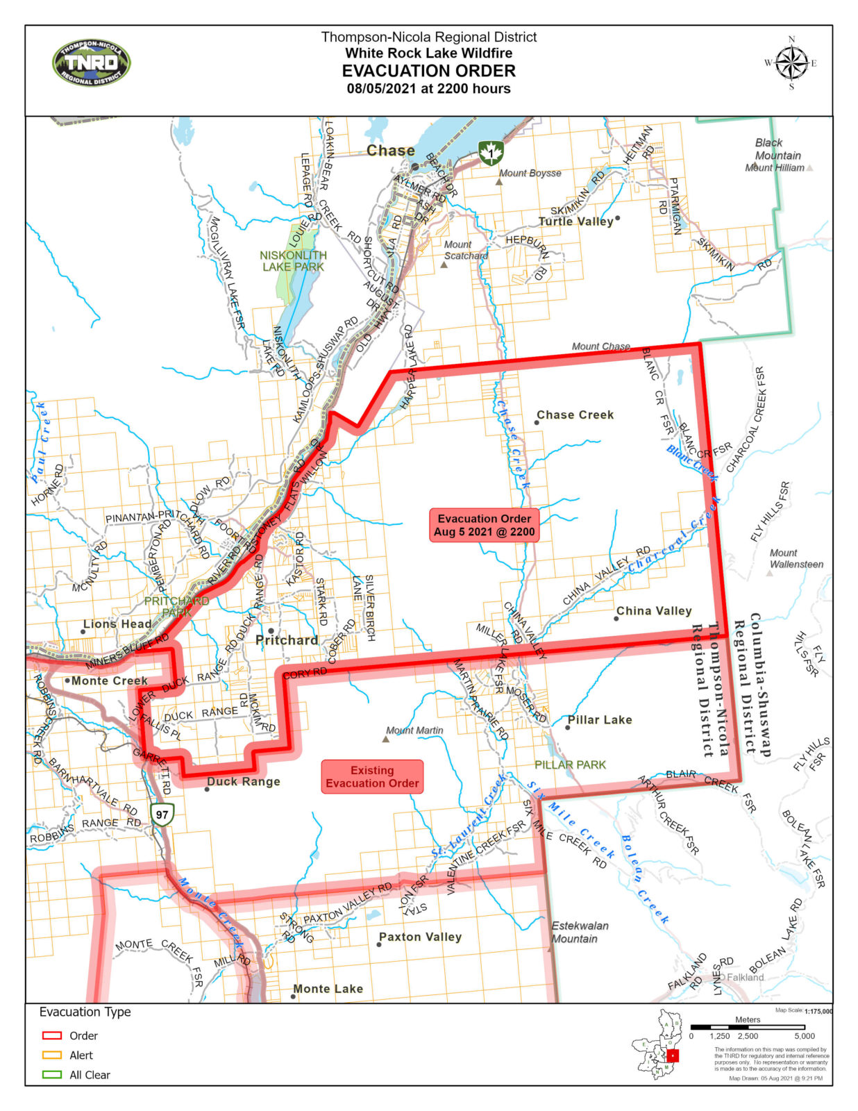
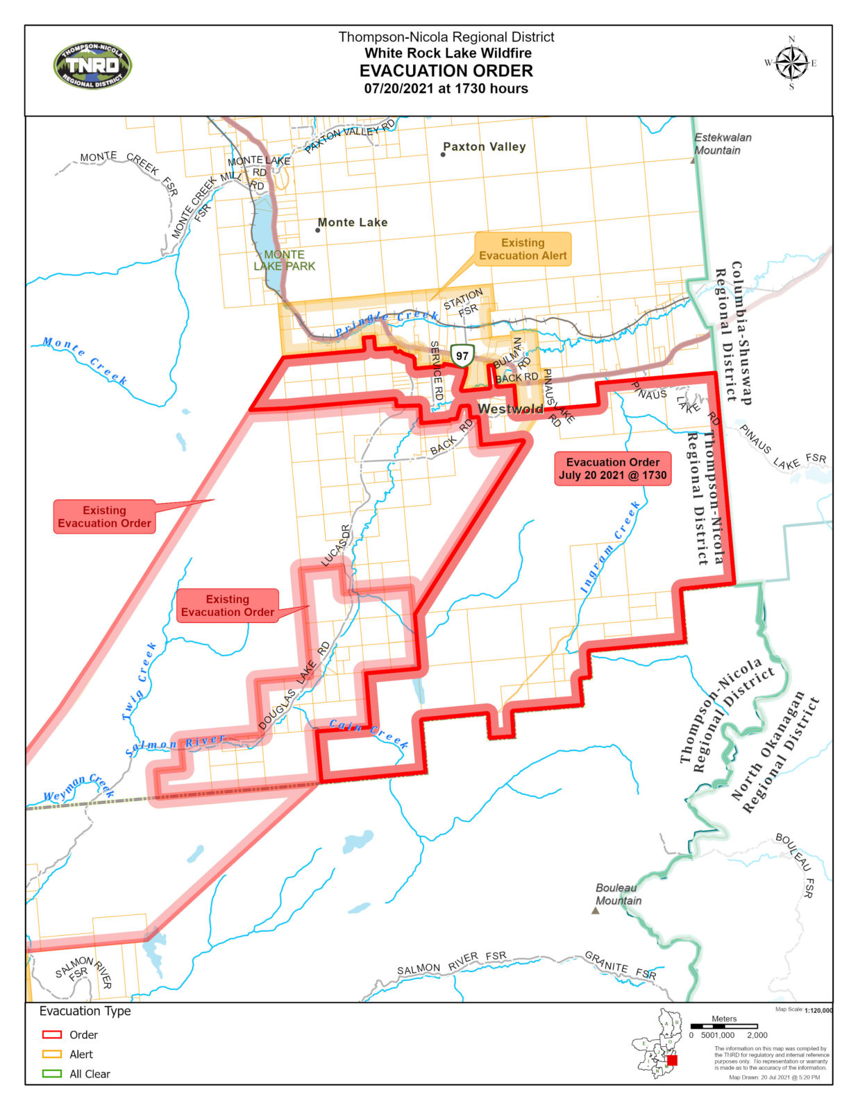