(UPDATE: Aug. 10 @ 10:50 am) - After reporting that the Nohomin Creek wildfire will be removed from the Wildfires of Note section of its website, the BC Wildfire Service provided more information on the 3,745-hectare blaze today.
The service said it will "remain an out-of-control wildfire until naturally extinguished."
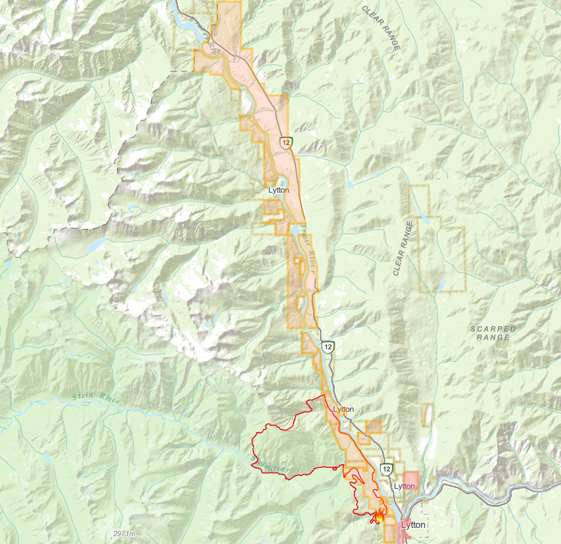
The fire is now burning entirely within the Stein Valley Nlaka’pamux Heritage Park and remains active in high-elevation sections of the valley.
"It will continue to produce smoke potentially visible to surrounding communities while burning conditions are present," the BCWS explained.
"Based on long-term fire behaviour modelling, there is no present or predicted threat to communities."
Lytton First Nation, who co-manages Stein Valley Nlaka’pamux Heritage Park alongside the Province, will regularly monitor growth of the Nohomin Creek wildfire.
(UPDATE: Aug. 9 @ 5:51 pm) - The Nohomin Creek wildfire burning approximately 1.7 km northwest of Lytton remains at an estimated 3,745 hectares.
BC Wildfire Services has announced that effective Aug. 10, this fire will no longer be considered a Wildfire of Note, as it no longer poses a potential threat to public safety.
While active fire behaviour is still noticed in the Stein Valley Nlaka'pamux Heritage Park, the fire remains in operable areas along steep cliffs, and rocky terrain.
BCWS is supporting the fire management strategy by organizing ground crews and aerial support, and smoke will continue to be visible in the park boundaries.
The fire's south, northeast, and east flanks remain stable with no active behaviour at this time.
Alerts and evacuation orders have been lifted for the wildfire, but the Thompson-Nicola Regional District noted they could be reinstated if necessary.
The cause of the fire remains under investigation but is believed to be human-caused.
(UPDATE: Aug. 6 @ 11 am) – Minimal growth has been recorded on the Nohomin Creek wildfire northwest of Lytton, thanks to a bit of precipitation and cooler temperatures.
In the latest update from the BCWS, the fire is now estimated to be 3,745 hectares – only 45 ha larger than the estimate on Friday.
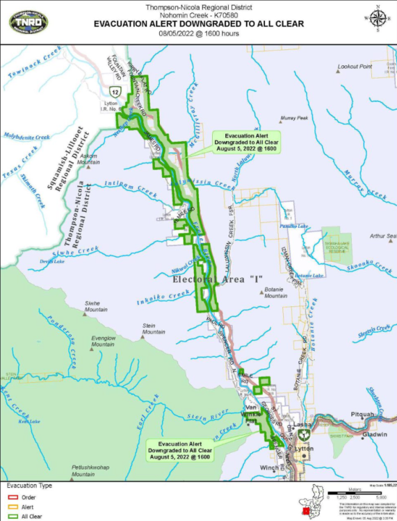
The Thompson-Nicola Regional District lifted an evacuation alert for 55 properties on Aug 5, effective at 4 pm.
“Should conditions change, an evacuation alert and/or evacuation order will be reinstated as necessary,” explains a release from the TNRD.
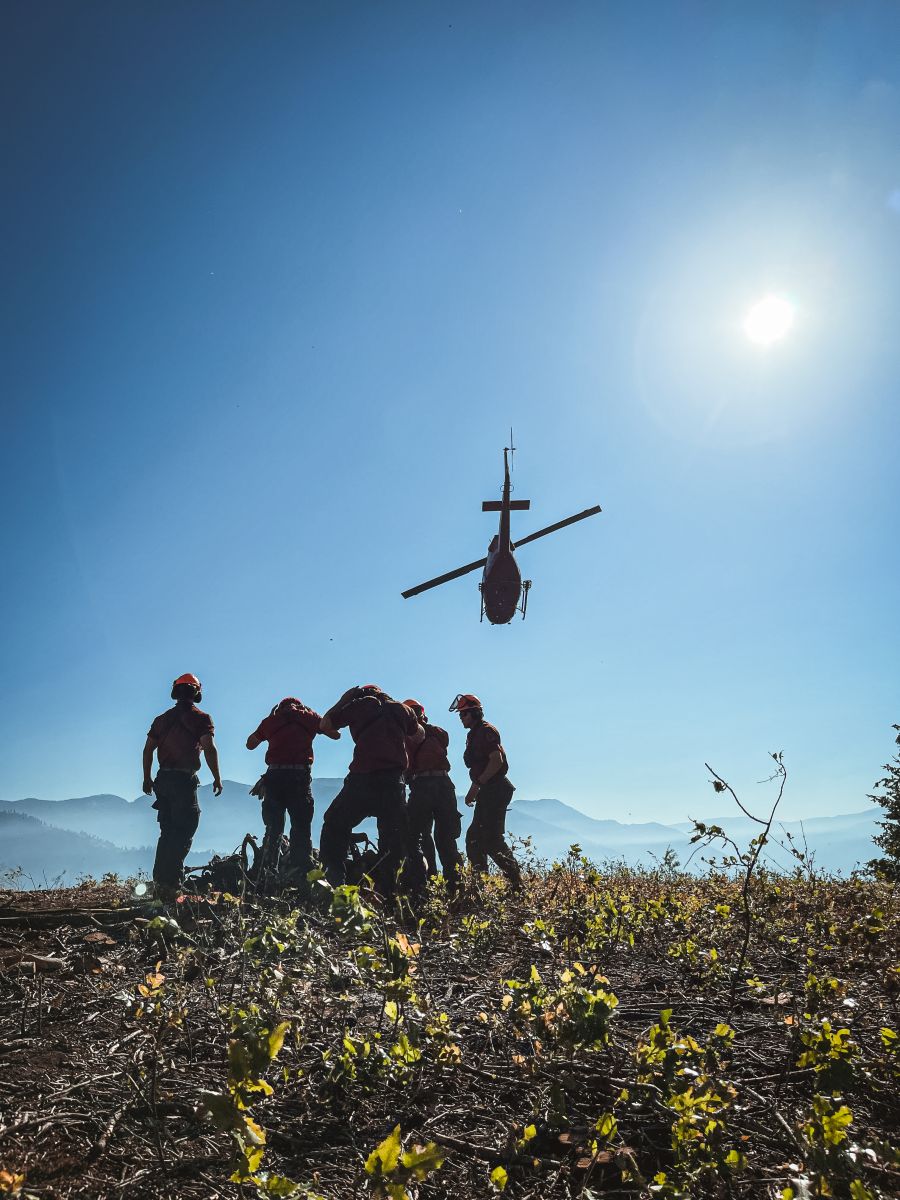
There are 51 firefighters and two helicopters on site Saturday.
Due to the heavy smoke in the area, air tankers and other resources are on standby.
“The fire's south, northeast, and east flanks remain stable with no active fire behaviour,” explains the BCWS update.
“There will continue to be active fire behaviour in the Stein Valley Nlaka'pamux Heritage Park. In this area, the fire is burning on steep cliffs, and rocky terrain ground crews cannot access.”
Despite a few days of cooler temperatures, crews are preparing for temperatures to return to above seasonal temperatures over the weekend, which could result in burning conditions that were experienced late last month.
(UPDATE: Aug. 5 @ 11:00 am): BCWS is reporting diminished activity on the Nohomin Creek wildfire, as current weather conditions are assisting in getting the fire under control.
The latest size of the fire is estimated to be around 3,700 hectares, which hasn't changed in the past two days.
Fire crews are unable to access the most active parts of the fire in the Stein Valley Nlaka'pamux Heritage Park, as is it burning on steep cliffs and rocky terrain.
"While the current precipitation and cooler temperatures will reduce fire behaviour over the next few days, temperatures are forecast to return to above seasonal this weekend and burning conditions will also return to what was experienced in late July," reports BCWS.
Lytton First Nation and BC Parks are co-managing fire management within the park's boundaries, and the BC Wildfire Service will support the fire management strategy by organizing ground crews and aerial support.
At this time there are 55 firefighters on the scene along with two helicopters, air tankers and other aerial resources are available based on operational needs as visibility and conditions allow.
The investigation into this wildfire remains ongoing, but at this time the incident is suspected to be human-caused.
An evacuation alert remains in effect for Lytton First Nation, and the most up-to-date information can be found online here or on the Thompson Nicola Regional District website.
(UPDATE: Aug. 3 @ 5:45 am): The Nohomin Creek wildfire has grown to 3,700 hectares, according to an estimate from the BC Wildfire Service.
The agency said last night that the 500-hectare expansion was in the northwest corner of the fire, north of the Stein River.
It was "contained with the Stein Valley Nlaka'pamux Heritage Park" and is moving west – away from communities – BCWS explained.
"In this area, the fire is burning on steep cliffs and rocky terrain that ground crews cannot access," the agency said.
"This is the most active part of the fire, and further growth is expected in the far northwest area of the wildfire."
The fire is stable in the north, south and east.
In its most recent update, BCWS said it had 112 firefighters, 11 helicopters and three pieces of heavy equipment battling the fire.
(UPDATE: Aug. 2 @ 9:40 am) – The Nohomin Creek wildfire did not experience any growth overnight and remains estimated at 3,162 hectares.
Crews also continue to battle the Maria Creek wildfire which was discovered on Sunday near Pavilion. It remains estimated at 45 hectares.
The BC Wildfire Service says there continues to be slow growth on the Nohomin Creek fire which is burning in high elevation areas, north of Stein River and west into the Stein Valley.
“In this area, the fire is burning on steep cliffs and rocky terrain where fuels are sparse and growth is driven by wind and gravity,” explains the agency.
“Temperatures are expected to decrease today as the ridge flattens, and fire behaviour will be primarily wind-driven as atmospheric conditions become more unstable.”
Fire growth will depend on the amount of wind, which is expected to increase Tuesday, and the availability of fuels.
The amount of moisture in the fuels will also influence fire activity over the coming days.
“Because of the delayed snowmelt this season, fuels at high elevations are more saturated than in valley bottoms,” explains the BCWS.
There are 79 firefighters on site Tuesday with support from 11 helicopters and three pieces of heavy equipment.
According to the latest update from BCWS, the steep terrain and hot weather continues to challenge crews and requires them to take frequent breaks to prevent heat exhaustion.
(UPDATE: Aug. 1 @ 12:21 pm) – The Nohomin Creek wildfire has grown again.
The BC Wildfire Service now estimates the fire to be 3,162 hectares.
The agency said it has 79 firefighters, 11 helicopters and three pieces of heavy equipment at the fire.
The Nohomin Creek firefighting team, meanwhile, has taken command of the response to another fire about six kilometres northeast of Pavilion.
That blaze – the Maria Creek wildfire – is estimated to be about 45 hectares.
It was caused by lightning.
BCWS added: "It is currently burning in inaccessible terrain, with dense timber, and exhibiting Rank 1 and Rank 2 fire behaviour. Fire behaviour will be influenced by moderate-to-high daytime temperatures, low relative humidity, and wind.
"Today, a 20-person unit crew and heavy equipment will be working to establish access to the fire and will be supported by helicopters."
The fire was discovered on Sunday at 3:30 pm, the agency explained.
Crews responded within 15 minutes.
(UPDATE: July 31 @ 10:40 am) – Minimal growth has been recorded on the Nohomin Creek wildfire, according to the BC Wildfire Service.
The fire is estimated at 2,910 hectares – up about nine hectares from Saturday.
Conditions remained hot and dry on Saturday as well. This caused some growth in higher elevations, north of the Stein River.
“Today, temperatures and low humidity are predicted to cause increased fire behaviour upslope of the Stein River,” explains the latest update from the BCWS.
“As a result, smoke will continue to be visible from Lytton and surrounding areas.”
Crews in the east have reported little-to-no fire activity and are working to extinguish five hotspots.
On the northern flank, crews continue to establish fuel-free lines and are installing a sprinkler system.
Crews in the south are patrolling and mopping up the fire’s perimeter between Stryen and Nohomin Creeks.
Structure protection is ongoing.
There are 89 firefighters, 11 helicopters and three pieces of heavy equipment on site Sunday.
(UPDATE: July 30 @ 10:20 am) – More accurate mapping has come in for the Nohomin Creek wildfire was started about 1.7 kms northwest of Lytton.
In an update posted at about 10 am, the BC Wildfire Service estimates the fire at 2,901 hectares.
This is up about 241 hectares from the Thursday, July 28.
There are 94 firefighters, 11 helicopters, and three pieces of heavy equipment on site Saturday morning.
(UPDATE: July 30 @ 9:20 am) – In the latest update from the BC Wildfire Service, the Nohomin Creek wildfire has grown nearly 300 hectares.
BC Wildfire Service now estimates the fire at 2,946 hectares – up from 2,660 estimated early Friday.
“Today, July 29, conditions were hot and dry, and fire activity increased again by mid-day,” explains the agency.
“There was minimal growth in the high elevation areas, however, the fire was quite active in steep, rugged terrain where access is limited.”
Helicopter crews were bucketing water onto the fire for much of the day Friday and managed to reduce fire behaviour in more active areas.
Fortunately, the BCWS says the fire continues to burn on rocky slopes with sparse fuels which has resulted in slower fire movement.
At this time the cause of the fire is suspected to be human caused, however, it remains under investigation.
BC Hydro personnel continue to work on fixing power poles and restoring power to a few remaining properties along the west side of the Fraser River.
On Friday, 94 firefighters were working on the site with an additional 20 people arriving later in the day.
They were supported by 11 helicopters and three pieces of heavy equipment.
(UPDATE: July 29 @ 11:10 am) - BC Hydro has announced this morning that a section of power lines lost in the Nohomin Creek wildfire has been "rebuilt and re-energized."
Sixty power poles were burned down by the fire in mid-July, the corporation explained.
Three transformer banks and two single transformers were also damaged, with 112 customers losing power as a consequence.
"BC Hydro was able to reconfigure the system and restore power to 39 customers the day the fire started, and then an additional 39 customers on July 24," the corporation said.
"At the height of repair efforts, about 30 BC Hydro personnel were working on rebuilding the line at one time, including crews from Lillooet, Cache Creek, Kamloops, Vernon and Salmon Arm."
The fire remains at 2,660 hectares.
In its most recent update, BC Wildfire Service said it had 94 firefighters at the scene of the blaze.
They are being supported by 11 helicopters and three pieces of heavy equipment.
The agency warned that "hot and dry conditions" are expected today, meaning fire activity "will likely increase again by mid-day."
It added: "Further growth is expected in the high elevation areas where access is inhibited by steep, rugged terrain. The rocky slopes and sparse fuels have slowed fire growth in certain areas.
"The fire is not moving at a significant pace and is not spreading further west into the Stein Valley at this time."
(UPDATE: July 29 @ 8:03 am) - The fire has now grown to 2,660 hectares.
BC Wildfire Service said last night that the fire is likely to intensify further in the coming days.
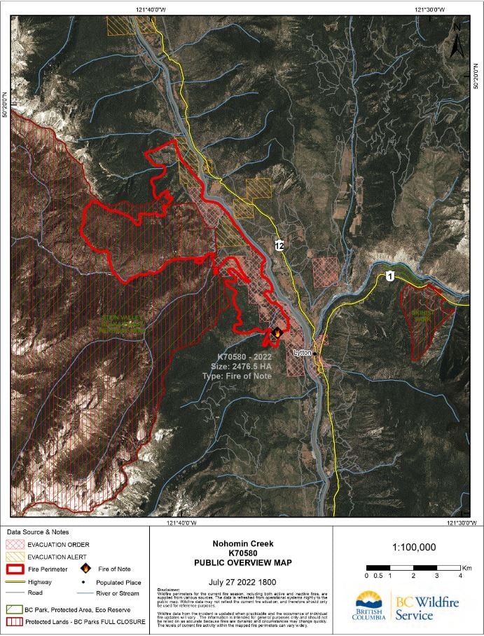
(UPDATE: July 28 @ 11:40 am) - The Nohomin Creek wildfire has grown nearly 100 hectares in the last two days and is now estimated at 2,476 hectares in size.
The BC Wildfire Service said high daytime temperatures on Wednesday led to increased fire behaviour at high elevations in the Stein Valley and temperatures are forecast to hit 41°C today.
"There’s a low risk of a dry-lightning event and associated winds in the vicinity of the fire," the BCWS explained. "This could increase fire activity as of mid-day, particularly on south-facing slopes."
Growth continues in the Stein Valley upslope along the west section of the fire, north of the Stein River, and crews are working to establish wet lines and fuel-free areas.
Crews are also patrolling the Stryen Creek area to extinguish the remaining hot spots.
"In recent days, the structure protection branch has installed 1,150 feet of hose and sprinkler systems, west, along the Stein Valley walking path," the BCWS noted.
"The purpose of this water delivery system is to increase fuel moisture content and relative humidity in valley bottoms, to protect park infrastructure and cultural values."
A spot fire sparked on the south side of the Stein River on Tuesday, but was contained by ground crews and aircraft.
While the west flank continues to be troublesome for crews, the north flank is considered stable.
Crews continue to establish containment lines to the south and mop up any remaining hot spots in the east.
At this time, the BCWS has 106 firefighters, 10 helicopters and three pieces of heavy equipment responding to the Nohomin Creek wildfire.
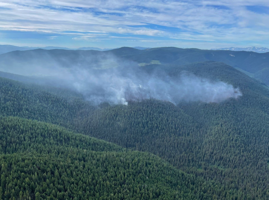
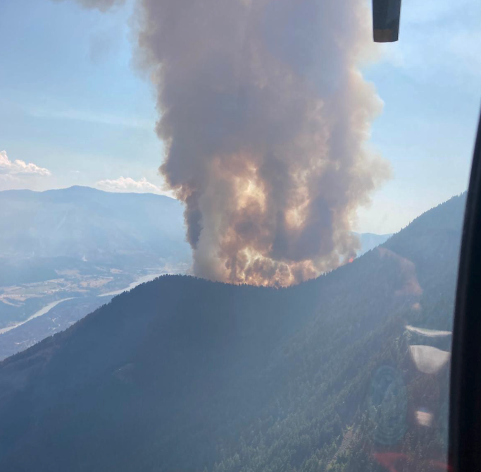
(Original story: July 26 @ 9:40 am) - Footage shared by the BC Wildfire Service on Monday night showcases what crews are dealing with while fighting the Nohomin Creek wildfire near Lytton.
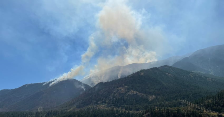
Captured earlier on Monday, the footage shows the western flank of the 2,364-hectare wildfire as it burns north of the Stein River.
“This section continues to be the most active and is burning in rugged terrain,” the BCWS explained.
“As temperatures rise and ground fuels continue to dry out, increased fire activity shown in this footage is expected to occur throughout the week.”
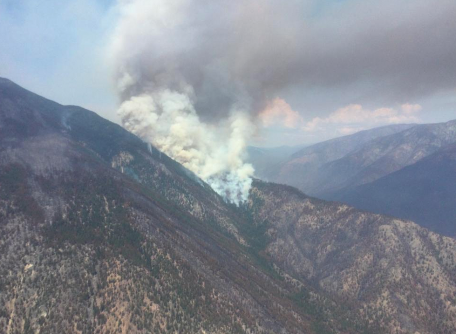
The BCWS added that the topography surrounding the Stein Valley is “exceptionally steep” with a number of cliffs and rock faces, which makes it inoperable for ground crews.
“Responder safety remains a top priority to the BCWS and placing any personnel on this section of the fire would be critically dangerous,” the service noted.
As expected, fire activity did increase on Monday and daytime highs are expected to consistently hit around 40°C in the region through Saturday.
Aerial infrared scanning was conducted on the eastern flank of the fire Sunday night and crews from Lytton First Nation and the BCWS continue to mop up any remaining hot spots in that area.
Crews to the north and south continue to make good progress towards containment as well, the BCWS explained, despite having to deal with the heat and difficult terrain.
“On the north side, the unit crew continue establishing hoselay as they continue to mop up the northwest flank of the fire,” said the latest BCWS update released this morning.
“Crews working along the southern portion of the western flank will be advancing their wetline 25 feet in from the fire perimeter. Initial attack crews patrol the Stryen Creek area and work to extinguish remaining hot spots.”
As seen in the video shared by BCWS, growth continues to occur on the west flank of the fire, north of the Stein River.
South of the river, however, initial attack crews are prepared to respond to any spotting that could occur.
“Crews established 1,100 feet of hoselay further west along the Stein Valley walking path and the systems were activated to run through the night,” added the BCWS.
“The hoselay and sprinkler system was extended to match the progression of the fire on the opposite side of the valley. The purpose of the sprinkler system is to add moisture into the valley bottom to protect park infrastructure and cultural values.”
NowMedia will continue to update this story as information becomes available from the BCWS.
To see our previous coverage of the Nohomin Creek wildfire, click this link.


