(UPDATE: Sept. 1 @ 11:20 am) – The McKay Creek wildfire is now classified as under control.
BC Wildfire Service (BCWS) explains a fire is under control when “has received sufficient suppression action to ensure no further spread.”
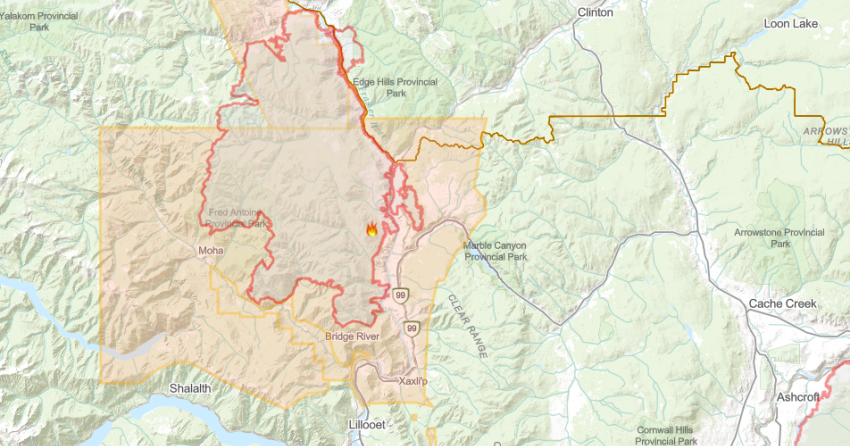
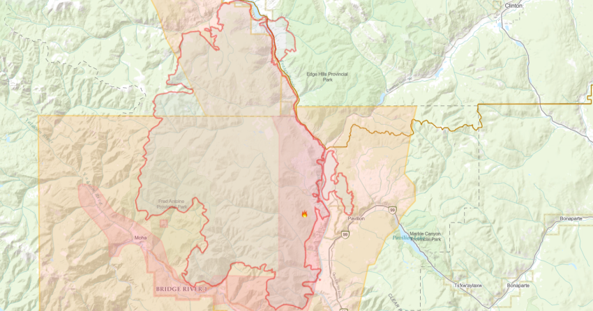
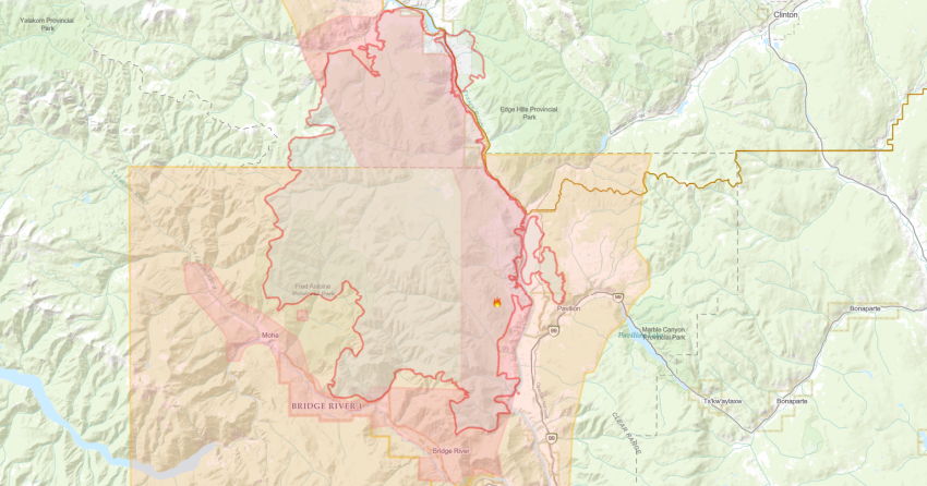
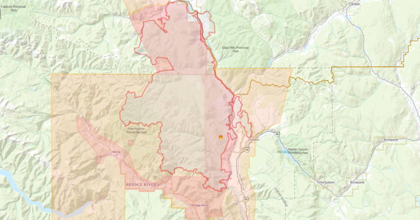
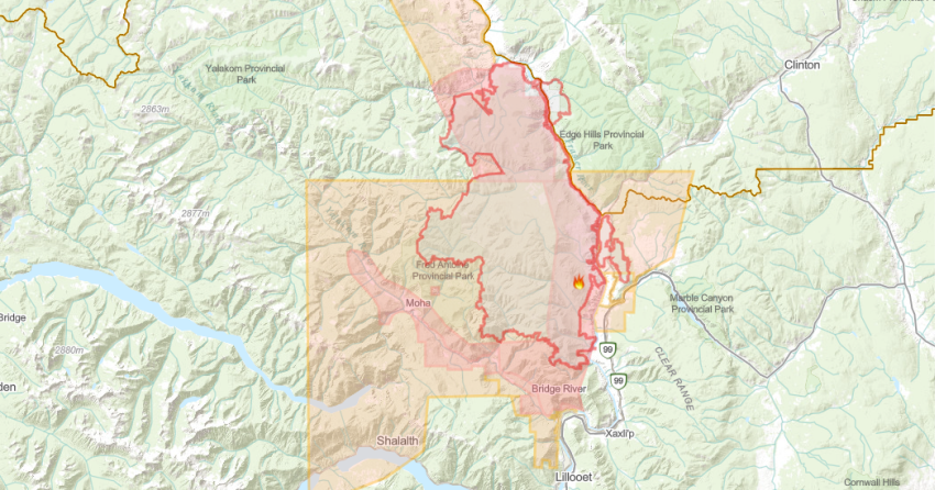
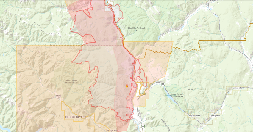
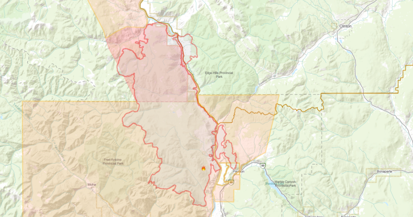
The fire was discovered on June 29 and burned an estimated 44,964 hectares.
It is suspected to be human caused but is still under investigation.
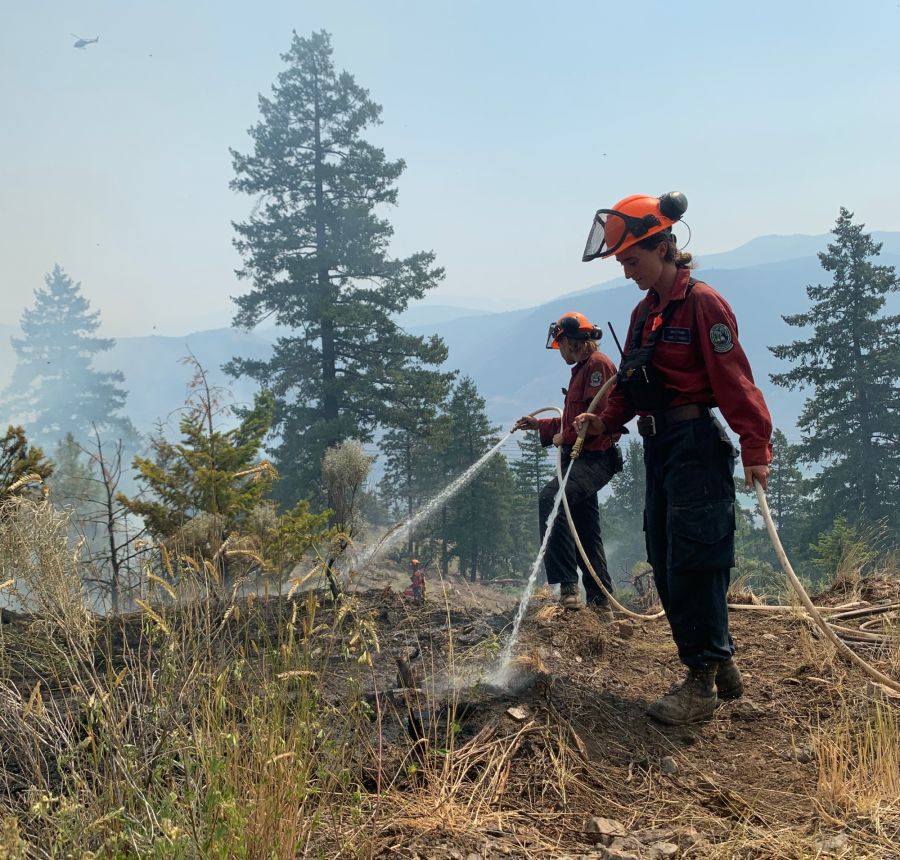
There are seven firefighters on site today who are continuing to mop up and patrol the fire’s perimeter.
According to BCWS, an initial attack crew from Lillooet is on site today and the fire will soon be transitioned back to the Lillooet Fire Zone.
The fire was being managed by the Lytton Creek Complex.
Resources have been sent to this fire as needed and a remote camera has been installed to ensure it has been continuously monitored.
The District of Lillooet has remained on “all clear” status since Aug. 22.
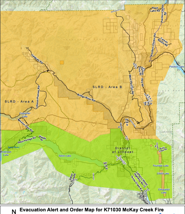
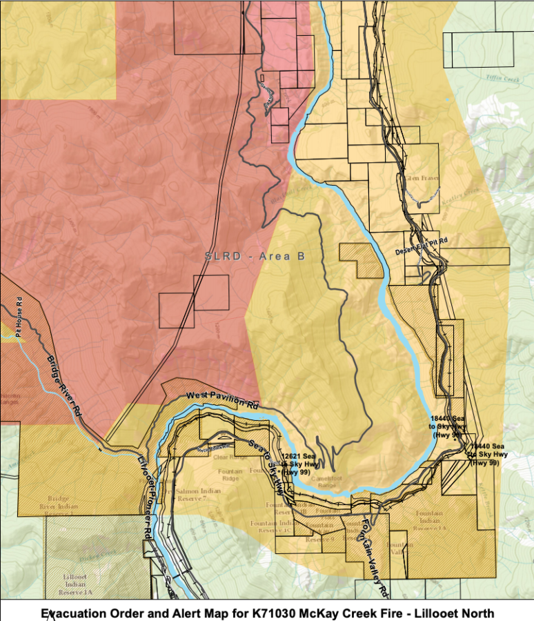
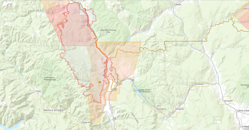
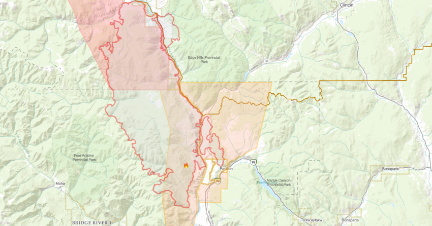
An evacuation alert, issued on Aug.22, does remain in place at this time for the Squamish-Lillooet electoral area “B.”
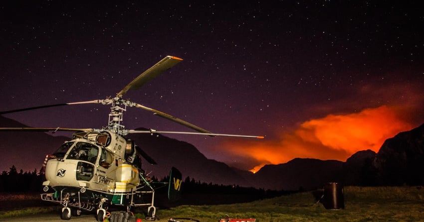
(UPDATE: Aug. 30 @ 10:52 am) - A remote camera was installed yesterday to monitor the McKay Creek wildfire, helicopters will also be utilized for additional monitoring.
The forecast is calling for cloud coverage and colder temperatures with the potential of showers in the evening, which will aid crews in containing the wildfire.
Minimal growth has been seen for the past several days, as it remains at an estimated 44,964 hectares.
The Incident Management Team for the Lytton Creek Complex remains in place, with four helicopters, and four structure protection teams being shared within the complex. Five firefighters are directly on scene.
The fire is suspected to be human caused but remains under an investigation.
Check within your district to find the most up to date information on evacuation alerts and order: Lillooet Municipality, Squamish-Lillooet Regional District, and the Cariboo Regional District.
(UPDATE: Aug. 29 @ 7:45 pm) – The McKay Creek wildfire continues to exhibit minimal fire activity and is still estimated at 44,964 hectares.
There are five firefighters assigned to the blaze that is located north of Lillooet.
BC Wildfire Service explains that “this fire is being continuously monitored and resources are being allocated to this fire based on operational need and resource availability.”
Helicopter crews continue to assist with suppression operations with a focus above Highway 40 between Yalakom and Applesprings.
BCWS notes that type one firefighters have moved into extinguish hotspots.
Type one firefighters are highly trained and work in areas with high fire activity.
On Thursday Aug. 26, a thermal scan was conducted along the southwestern flank and crews are actioning hotspots that were identified.
BCWS confirms that “the scan picked up very few hotspots, a positive sign for fire suppression progress.”
All structural protection equipment has been disassembled from the Yalakom and Applesprings area.
An evacuation alert remains in place for the Squamish-Lillooet electoral area “B” for the Yalakom Valley, Lillooet-Pioneer Road, Pavilion and West Pavilion areas.
(UPDATE: Aug. 27 @ 2:30 pm) - It continues to be positive news coming from the frontlines of the McKay Creek wildfire.
The fire north of Lillooet remains at 44,964-hectares and the BC Wildfire Service said "no fire growth has been observed over the last seven days."
Helicopters continue to bucket as necessary along the south perimeter, while crews are attacking hot spots through on-the-ground suppression.
"Last night, a drone team conducted infrared scanning along the southwestern perimeter of the McKay Creek Wildfire to look for hot spots," the latest BCWS update said.
"Cooler nighttime temperatures also help provide more accurate heat sensor readings. The heat sensor picked up very few hot spots, a positive sign for fire suppression progress."
As a result, crews can now go in and action the identified areas.
There are just five firefighters manning this fire at this time, suggesting that it could transition to "being held" status soon.
Check within your district to find the most up to date information on evacuation alerts and order: Lillooet Municipality, Squamish-Lillooet Regional District, and the Cariboo Regional District.
(UPDATE: Aug. 26 @ 1:08 pm) - Drone crews are expected to conduct infrared scanning in the Applesprings area tonight, as cooler nighttime temperatures provide a more accurate heat sensor reading.
The scans will help identify hotspots that otherwise may not be visible, and BCWS will then prioritize those areas for suppression.
The McKay Creek wildfire has seen minimal activity apart from the few remaining hotspots that helicopters have been bucketing along the southern perimeter, primarily above Hwy 40 between Yalakom and Applesprings.
The Bridge River Guard in the Applesprings area is complete, as well as struction protection around Yalakom and Moha.
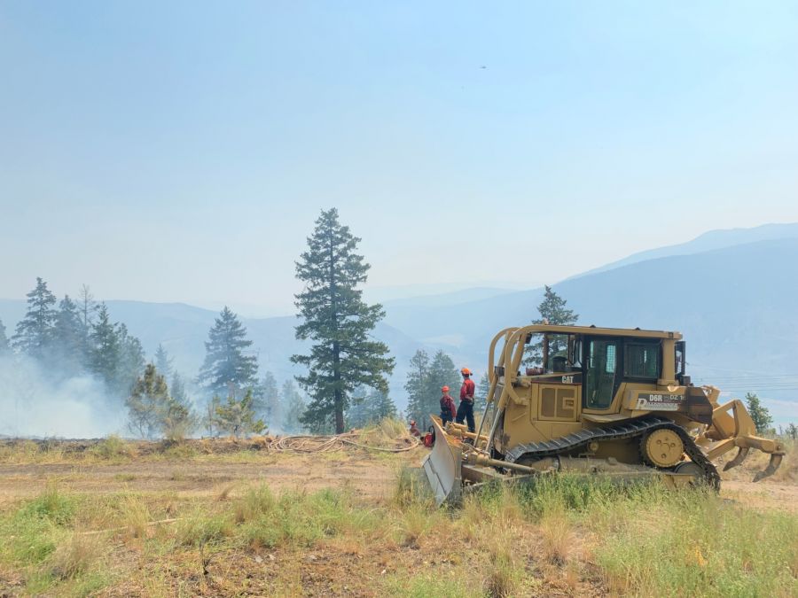
There are currently five firefighters working with one piece of heavy equipment on this fire; an incident management team is in place for the Lytton Creek Complex which includes McKay Creek.
There are 16 structure protection teams and five helicopters being shared within the complex.
The fire remains at an estimated 44,964 hectares, and smoke is highly visible along the Hwy 40 corridor. There is currently no threat to the road.
The fire is suspected to be human caused but an investigation remains underway.
Check within your district to find the most up to date information on evacuation alerts and order: Lillooet Municipality, Squamish-Lillooet Regional District, and the Cariboo Regional District
(UPDATE: Aug. 23 @ 11:40 am) – The McKay Creek wildfire has grown another 300 hectares and is now estimated at 44,964 hectares.
The area did receive between three and 23 millimetres of rain yesterday and last night.
Temperatures dropped quite a bit in the area with lows of three to five degrees reported overnight.
BCWS is forecasting a cloudy day with a chance of showers and temperatures between 15 to 18ºC.
The District of Lillooet is no longer on evacuation alert, effective Aug.22
The Thompson-Nicola Regional District downgraded an evacuation order to an alert for two properties in electoral area "E" (Bonaparte Plateau).
The Squamish-Lillooet Regional District also downgraded an evacuation order to an alert for electoral areas “A” and “B.”
The SLRD rescinded an evacuation alert for electoral area “B” (Texas Creek area).
The properties moved to “all clear” include:
- All addresses in Seton Portage, excluding the Highline Road
- Balbirnie Rd
- Bouvette Rd
- Bridge River Rd / Lillooet Pioneer Road 40, from the District of Lillooet to Seton Portage
- Fountain Valley Rd from Hwy 99 and south for 18kms
- Frantzen Rd
- Lillooet-Pioneer Rd
- Lytton-Lillooet Highway No 12 from Hwy 99 and south for 12km
- Mission Dam Road
- Munson Rd
- Powerhouse Rd
- Roshard Rd
- Rusty Creek Rd
- Seton Lake Rd
- Seton Retask
- Shinta Rd
- Texas Creek Rd from Hwy 99 and south for 9km
- Timber Road
- Welsman Rd
Not much has changed in regard to the crew numbers, there are still 11 firefighters, four helicopters and two pieces of heavy equipment on site today.
Although the fire has grown this week, BCWS explains that “fire activity has been quiet throughout most of the perimeter."
The southwest flank of the fire continues to be the most active despite the rainfall.
Crews are focusing their efforts in this area to prevent the fire from spreading and impacting Highway 40.
(UPDATE: Aug. 22 @ 7 pm) – The McKay Creek wildfire has grown significantly since Wednesday when it was recorded at 41,688 hectares.
Today, BCWS is estimating the fire to be burning at an estimated 44,688 hectares.
There are 11 firefighters, four helicopters and two pieces of heavy equipment assigned to the fire.
Although the fire has grown around 3,000 hectares, BCWS explains that the area has received rain while the high for today is 15ºC with light southwest winds.
The District of Lillooet remains on evacuation alert.
Multiple evacuation notices, issued by the Squamish-Lillooet Regional District, remain in effect:
The Thompson-Nicola Regional District downgraded an evacuation order to an alert for two properties in electoral area "E."
BCWS is not expecting any significant fire activity in the coming days and the majority of activity has been minimal – except on the southwest flank.
Yesterday, Aug. 21, saw warmer temperatures and winds as crews observed an increase in fire behaviour on this flank.
“Fuel is sparse along the steep slopes but there is a risk of burning material rolling down towards the Highway 40 corridor,” the agency notes.
Helicopter crews are working to cool the fire perimeter that is closest to the highway.
On the western flank, near Applesprings Creek, crews continue to mop up hotspots with the support of helicopters.
Construction on the Bridge River fire guard in this area is almost complete.
Crews also finished setting up structural protection equipment in the Yalakom and Moha areas.
(UPDATE: Aug.18 @ 11:20 am) – The McKay Creek wildfire is now estimated at 41,688 hectares.
There are 26 firefighters, nine pieces of heavy equipment and two helicopters on site today.
The fire did receive rain and cooler temperatures as BCWS reports “amounts ranging from 2mm in the north to 24mm in the south.”
Crews continue to work in the Applesprings area, extinguishing hotspots with the support from helicopter crews.
The Fred Antoine Park and surrounding communities remain a priority to the BCWS crews.
Warm and dry conditions are expected to return in the coming days.
However, BCWS is forecasting lighter winds, cooler overnight temperatures and higher humidity.
“The cool, wet weather limited fire activity in the fine fuels, like grasses, but these are expected to dry out again and become more likely to burn by Wednesday or Thursday afternoon,” explains BCWS.
An evacuation alert for electoral areas “A” and “B” in the Squamish-Lillooet Regional District remains in effect.
An evacuation order for electoral areas “A” and “B” (Yalakom Valley) also remains in effect.
Visit slrd.bc.ca for more information on evacuation notices.
(UPDATE: Aug. 17 @ 12:30 pm) - The McKay Creek wildfire is now an estimated 41,110 hectares after extreme fire behaviour was noticed in the evening.
An incoming cold front is expected today which will bring cooler temperatures and rain to the complex. Winds will shift northwest, 15 to 25 km/h and minimal fire activity is expected based on the forecasted cooler temperatures, precipitation, and higher relative humidity.
While the rain is helping slow fire growth in fine fuels, larger fuels continue to burn. Mudslides along Hwy 1 between Cache Creek and Lytton have created challenges for crew movement, limiting access for some planned wildfire response activities.
Structure Protection Personnel have deployed sprinklers, pumps, and water supply systems in the Xwisten (Bridge River Indian Band) and Applesprings Creek communities.
A fireguard is in place around these communities and BCWS Incident Management Team and Operations personnel are considering all available options to protect communities of Xwisten (Bridge River), Applesprings, Moha, and Yalakom Valley. The community of Lillooet is NOT threatened by this fire activity.
Fire managers are coordinating closely with community council, emergency operations centres and EMBC.
There are currently 31 firefighters, nine pieces of heavy equipment, four line locators, and two helicopters assigned to this wildfire.
Evacuation orders and alerts remain in place for properties in Squamish-Lillooet Regional District and the Thompson Nicola Regional District.
(UPDATE: Aug.16 @ 6:30 pm) – The McKay Creek wildfire originated approximately 11km north of Lillooet and was discovered June 29.
BC Wildfire Service is estimating that this fire is burning 37,395 hectares.
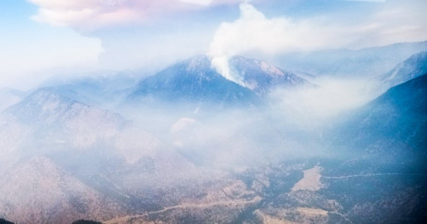
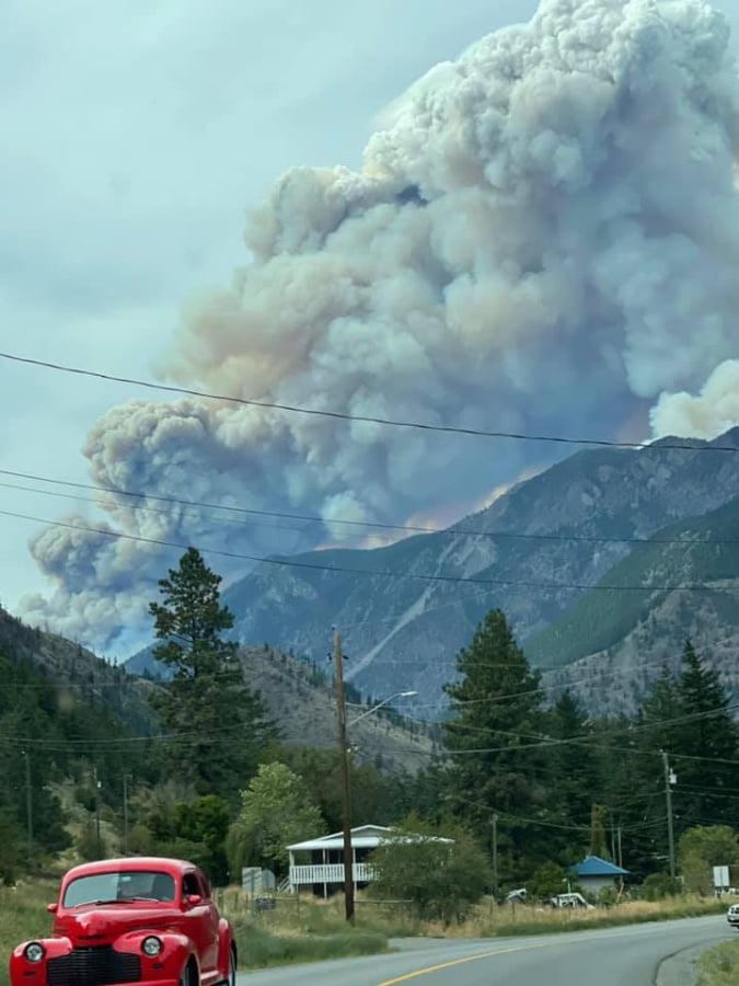
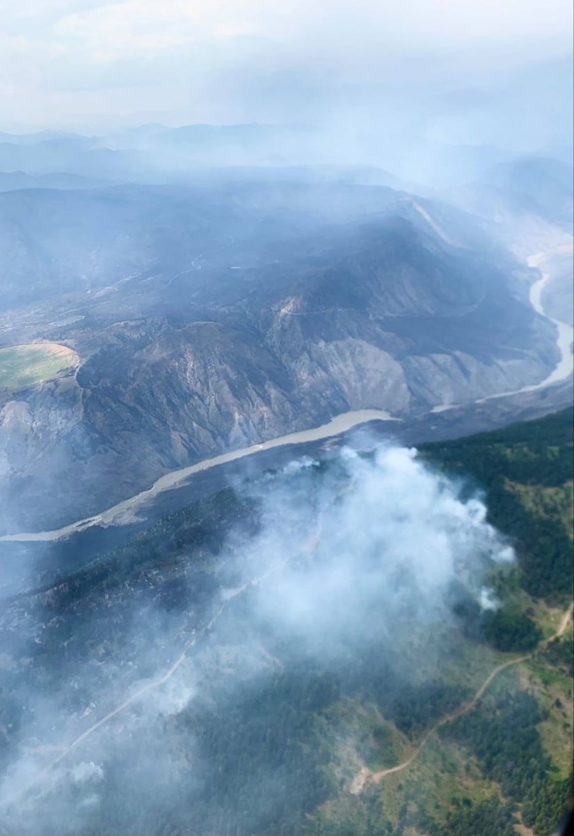
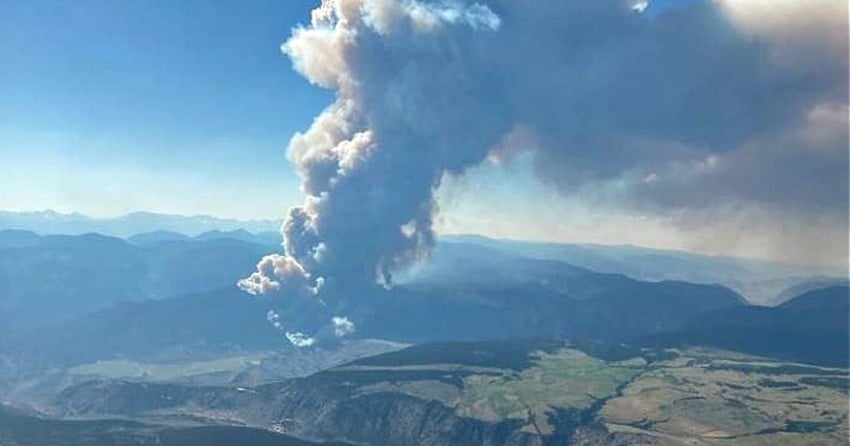
“Extreme fire behaviour is taking place on the west side of the fire. A large smoke column is visible in the region, including from the communities of Lillooet and Clinton,” the agency explains.
BCWS assures residents of Lillooet that the community is not threatened by the fire activity.
There are 29 firefighters, two helicopters and 15 pieces of heavy equipment assigned to this fire today.
Crews continue with suppression efforts in the Applesprings Creek area as they try to keep the fire on the western side of the drainage area.
BCWS expects an increase in fire activity in the Applesprings Creek, Fred Antoine Park and Black Hill areas today.
Planned ignitions, however, are not going to be implemented in the Applesprings Creek area today.
Structural protection personnel and equipment was sent to communities in the Yalakom Valley.
On Sunday, Aug.15, the Squamish-Lillooet Regional District issued an evacuation alert for portions of electoral area “A” and electoral area “B.”
All other evacuation orders and alerts issued by the SLRD remain in effect.
(UPDATE: Aug. 14 @ 7:30 pm) – The McKay Creek wildfire is now estimated to be burning at 36,188 hectares – a 3,578 hectare jump since Wednesday.
There are 39 firefighters, two helicopters and 10 pieces of heavy equipment assigned to this fire.
BC Wildfire Service (BCWS) explains that “hotter and drier weather led to increased fire behaviour.”
“Extremely vigorous surface fire and an active crown was present on the west flank of the fire. A strong smoke column was highly-visible from nearby communities and travel corridors such as Highway 99 and Highway 40.”
The western flank remains the most active flank near Antoine Creek and Applesprings Creek with smoke visible from surrounding areas.
Today, air resources are working to suppress the fire activity in these areas.
Structure protection personnel are deploying equipment in the Bridge River Indian Band and Applesprings Creek communities.
BCWS notes that Lillooet is not threatened by this recent fire activity.
The agency has not chosen to implement planned ignitions as of 2 pm due to unfavourable conditions.
On Aug. 13, the Squamish-Lillooet Regional District issued an evacuation order for electoral areas “A” and “B” (Yalakom Valley). Visit this link for more information.
The evacuation order for electoral area “B” (Lillooet-Pioneer Road) remains in effect.
The evacuation order for electoral area “B” (West Pavilion area) also remains in place.
(UPDATE: Aug. 11 @ 11:50 am ) - BC Wildfire Service crews are expected to have their hands full again at the McKay Creek wildfire.
The agency reported low fire activity and minimal growth over the past two days, but hotter and drier conditions, as well as some wind out of the north, has ramped up activity again today.
"Conditions are expected to become warmer and drier through the week and fire activity is expected to increase," explained the BCWS.
Crews are continuing mop up operations in the Lee Creek area, while a 20-person unit crew is digging a hand guard tying the West Pavilion Road into natural features to create a larger control line.
The evacuation order issued by the Squamish-Lillooet Regional District on Aug. 5 for electoral area “B” (Lillooet-Pioneer Road) remains in place.
The evacuation order for electoral area “B” (West Pavillion Area) also remains in place.
At this time, 26 firefighters, six pieces of heavy equipment and two helicopters are assigned to this fire.
(UPDATE: Aug. 8 @ 6:30 pm) – The McKay Creek wildfire has grown significantly since Thursday and is now burning at 32,610 hectares.
However, BC Wildfire Service (BCWS) reports that the fire received around 15-20 millilitres of rain and is demonstrating rank one fire behaviour.
Saturday Aug. 7 also saw rank one fire activity, with a few areas showing rank two behaviour.
Visit this link to learn more about the ranking system used for wildfires in BC.
The cause of this fire remains under investigation as it continue to burn out of control.
Today, there are 26 firefighters, two helicopters and nine pieces of heavy equipment assigned to this fire.
“Personnel completed an aerial reconnaissance flight yesterday and are preparing containment lines for potential planned ignition operations,” affirms BCWS.
Crews will continue to mop up in the Lee Creek area and establish guards that connect the West Pavilion road to natural guards (such as creeks).
More fire guards will be built in the southern flank of this fire to the north of Applespring Creek.
Heavy equipment will move in and complete this work in the coming days.
The evacuation order issued by the Squamish-Lillooet Regional District on Aug. 5 for electoral area “B” (Lillooet-Pioneer Road) remains in place.
The evacuation order for electoral area “B” (West Pavillion Area) also remains in place.
Thumbnail picture photo credit: courtesy of Ian Routley.
(UPDATE: August 5 @ 12:00pm) - The McKay Creek wildfire is now estimated to be 29,019 hectares.
BCWS saw a significant increase in fire activity yesterday on the west flank of the fire, based on the forecast there's potential for similar behaviour today.
The wildfire is highly visible from surrounding communities and travel corridors, including Hwy 99, but the road remains open as it has not been impacted by the fire.
"Fire growth continues into the Applespring Creek drainage, and on the north flank toward Watson Bar Road. The fire has crossed West Pavilion Road in some locations to the north," said BCWS.
Heavy equipment continues to construct a fire guard on the north flank.
Yesterday an evacuation order was issued by the Squamish-Lillooet Regional District for the area of West Pavillion, Electoral Area B.
This fire is suspected to be human-caused but still under investigation.
(UPDATE: Aug. 3 @ 3:45 pm) – The McKay Creek fire has grown slightly since Sunday and is now burning at 27,811 hectares.
Today, there are 19 firefighters, two helicopters and nine pieces of heavy equipment working on this fire.
The fire continues to grow in the western flank near Applespring Creek and the northern flank near West Pavilion Road and Watson Bar Creek.
BCWS notes that fire has crossed the West Pavilion road in some places along the northern flank.
BC Wildfire Service reports that “ground crews are working to establish a hose-lay while heavy equipment works to construct a fire guard on the north flank of the fire, along West Pavilion Road.”
BCWS also continues to assess opportunities to engage in planned ignitions.
A thermal scan was completed and crews engaged in mop up and patrolling operations.
Visit tnrd.ca for more information on the evacuation orders and/or alerts in place for electoral area “E” (Bonaparte Plateau).
(UPDATE: Aug 1 @ 5 pm): The BC Wildfire Service continues to battle the McKay Creek blaze.
As of today, the blaze sits at 26,472 hectares in size. It is still classified as out of control.
Increased fire activity has been observed on the western flank. Additional growth to the north has also been reported.
"Significant fire activity continued on the southwest flank in the Slok Creek area yesterday, July 31." Fire movement is primarily to the west toward Applespring Creek and Fred Antoine Park."
"Fire crews are unable to engage in direct attack in these areas. The Squamish-Lillooet Regional District has issued an Evacuation Alert because of this growth."
A total of 35 firefighters, two helicopters and nine pieces of heavy equipment are working on the blaze. More to come.
(UPDATE: July 29 @ 10 am) – The fire is burning at an estimated 25,122 hectares.
Crews continue to work on the northwest flank near an old mining camp in the Second Creek area.
This area has a fire guard, control line, a hose and sprinklers established.
Today, crews will engage in “direct attack” in this area while being supported by helicopters.
Specialists continue to determine future opportunities for more controlled ignitions in the area.
The goal of those controlled ignitions will be to “bring the perimeter of the fire to an area that is workable for ground crews,” reports BC Wildfire Service.
Crews completed thermal scans in the south and east flanks to determine the location of hotspots.
Visible smoke was produced from increased fire activity in the southwest flank, however, heavy equipment crews have established a guard in the area.
There are 28 firefighters, two helicopters and 9 pieces of heavy equipment working on this fire today.
Visit these links for more information on the evacuation orders and alerts issued by the Thompson-Nicola Regional District.
(UPDATE: July 27 @ 11:00 am) - The Mckay Creek wildfire has gone down in size and is now an estimated 24,963 hectares.
There are currently 31 firefighters, eight pieces of heavy equipment, and three helicopters on scene battling the blaze.
Crews continue working on the southwest flank of the fire, at the north end of Lee Creek as the fire has challenged control lines in this area in recent days, which has resulted in an excursion to the west.
Crews have established a hose lay and set up a sprinkler line to help prevent further spread.
BCWS says that they "Continue to action the fire with the assistance of helicopter bucketing, while heavy equipment and ground personnel continue work on a fire guard that will connect to West Pavilion Road on the west side of Second Creek."
Opportunities for aerial ignitions continue to be examined.
The east and south flanks continue to experience little fire activity, and a thermal scan of the area last night was conducted to identify any remaining hot spots.
On July 24, the Thompson Nicola Regional District (TNRD) partially downgraded the evacuation order to an evacuation alert in electoral area "E" (Bonaparte Plateau).
An evacuation order remains in place for some of this area.
The fire is suspected to be human caused, but still under investigation.
(UPDATE: July 22 @ 6:00 pm) – The Mckay Creek wildfire saw small growth and is now estimated at 25,120 hectares.
The evacuation alert for the West Pavilion Road from the 14km mark to the 41km mark in Electoral Area B, and for the Pavilion area in Electoral Area B remains in place.
Visit slrd.bc.ca for more information.
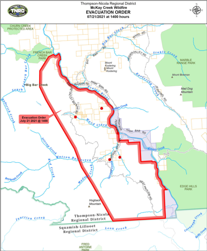
The Thompson-Nicola Regional District has declared an evacuation order for five properties in Electoral Area “E” (Bonaparte Plateau) effective July 21 at 4:31 pm.
Crews continue to secure priority areas and reduce the speed of the fire.
They were also able to complete a fire guard on the southwest flank to protect local communities and stop the fire from spreading south.
The area saw high winds yesterday so there was some increased activity on the northwest flank of this fire.
Helicopter crews continue to perform direct suppression efforts while ground crews extinguish hot spots to limit the spread in the east and south flanks of the fire.
Today, there were four helicopters, 75 personnel and six pieces of heavy equipment working on this fire.
(UPDATE: July 19 @ 12:10pm): Mckay Creek wildfire has shown little growth over the weekend and is currently sitting at an estimated 24,805 hectares.
BC Wildfire Service (BSWS) says their main objective is to secure priority areas and reduce spread primarily in the north, east, and south ends of the fire.
If weather conditions are favourable, as winds continuing to be moderate with no precipitation in the forecast, a planned ignition may take place on the southwest flank in the coming days.
The ignition operation helps crews prevent further fire spread, which would be planned for the north end.
Crews have been working to extinguish a number of hot spots found through thermal scanning this past week, and helicopters are bucketing on perimeter of the fire.
The Thompson-Nicola Regional District has also issued an evacuation alert for five properties in the Bonaparte Plateau area in Electoral Area E, with an evacuation alert remaining in the both the Pavilion and West Pavilion.
There are currently 105 personnel fighting the McKay Creek fire working alongside four helicopters, and nine pieces of heavy equipment
(UPDATE: July 16 @ 10:15 am): The McKay Creek wildfire still remains at and estimated 24, 457 hectares, but increased fire behaviour has been noticed by BCWS.
Crews have been using thermal scanning to identify areas of concern and plans to do another sweep later this evening.
BCWS continues to secure priority areas, and reduce spread, there are currently 100 personnel on scene working alongside four helicopters and 10 pieces of heavy equipment.
In the South flank fire crews are mopping up and patrolling along the West Pavilion Road and the Lee Creek guard. The overnight thermal scan on July 13th revealed a number of hot-spots.
The West flank is currently using heavy equipment, hoses were laid yesterday and will continue today to be ready in the event of a burn out within the fire guard. Fire behaviour was observed again within the Slock Creek area. However, there are no concerns at this time. The fire in this section is burning the previously unburnt fuels and saw limited growth.
The North flank above the old mine site has seen increased activity, but there is good containment in place and it will be carefully monitored.
The East flank currently has direct suppression on the perimeter as the fire continues above the community of Pavilion.
With dry temperatures and variable winds, fire behaviour may continue to increase in the coming days.
The Squamish-Lillooet Regional District has rescinded the Evacuation Orders for the West Pavilion Road from the 14km mark to the 41km mark in Electoral Area B, and for the Pavilion area in Electoral Area B.
An Evacuation Alert remains in place for both the Pavilion and West Pavilion.
(UPDATE: July 8 @ 12:50 pm) - There hasn't been much growth on the McKay Creek wildfire in recent days.
The BC Wildfire Service's current size estimate for the fire is 25,015 hectares.
Updated mapping has the border of the fire just 11.5 kilometres from Lillooet, as it was previously listed as 23 km away.
There are 165 BCWS personnel working on the McKay Creek fire with assistance from 15 helicopters and 20 pieces of heavy equipment.
They also got assistance from Mother Nature on Wednesday, as 5-10 millimetres of rain fell in the area.
Evacuation orders remain in effect through the Squamish-Lillooet Regional District, while the Thompson-Nicola Regional District has evacuation alert in place as well.
An area restriction remains in place for the fire as well, which you can view here.
(UPDATE: July 6 @ 8:20 am) - More accurate mapping from the BC Wildfire Service has resulted in a new size estimate for the McKay Creek wildfire.
The fire burning 23 kilometres northwest of Lillooet is now considered to be 24,698 hectares.
More than 100 BCWS personnel are working tirelessly to prevent spread of the fire, along with the help of 14 helicopters and 21 pieces of heavy equipment.
Crews are making good progress in the southeast section of the fire and a guard has been completed in the vicinity of Lee Creek.
"Crews conducted small-scale ignitions against the guards on and below the West Pavilion Forest Service Road and continued with mop-up," explained the BCWS.
"Today, if conditions permit, there are planned ignitions to bring the fire down to the Lee Creek guard which is safer and more operable ground for the crews."
The BCWS added that the combination of aerial and hand ignitions will produce smoke that's visible from Hwy 99.
On the southwest corner of the fire, east of the Fraser River, heavy equipment has completed guards above the community of Pavillion.
Another guard parallel to the transmission lines is expected to be completed today as well, while crews will also establish a hose lay and continue with mop-up.
Evacuation orders have been put in place by the Squamish-Lillooet Regional District, while the Thompson-Nicola Regional District has a small evacuation alert in place as well.
There also an area restriction in place for the McKay Creek fire and surrounding area.
(UPDATE: July 5 @ 8:25 am) - The latest mapping from the BC Wildfire Service estimates a wildfire 23 kilometres north of Lillooet to be 26,301 hectares in size.
"(On Sunday), the Mckay Creek fire experienced lower fire behavior with less erratic winds, cooler temperatures and higher relative humidity," explained the BCWS.
Crews have been working hard to extinguish hot spot and conduct small-scale ignitions to remove unburnt fuels.
Last night, firefighters remained on site to monitor the area while heavy equipment worked on a containment line in the vicinity of Lee Creek.
East of the Fraser River, on the southwest corner of the fire, a guard was completed around the community of Pavillion this weekend.
Overall, there are 109 BCWS personnel working on the McKay Creek fire with the assistance of 14 helicopters and 13 pieces of heavy equipment.
Evacuation orders are in effect, which you can learn more about here.
(UPDATE: July 1 @ 8:05 am) - The McKay Creek fire, which is burning around 23 kilometres north of Lillooet, continues to exhibit significant growth.
The out-of-control wildfire is now up to 22,000 hectares, as it's fueled by elevated winds.
"The fire has now crossed the Fraser River and is burning in isolated areas on the east side of the river," explains the BC Wildfire Service.
"Due to the aggressive fire behaviour and windy conditions, crews' progress on the fire has been limited."
The interface fire has resulted in a number of evacuation orders and alerts being put in place by the Squamish-Lillooet Regional District, which you can learn more about here.
Still believed to be human-caused, the fire is producing smoke that's highly visible from Lillooet, Clinton and other surrounding communities.
NowMedia will continue to update this story as more information becomes available.
(UPDATE: July 1 @ 8:40 am) - The wildfire burning out of McKay Creek near Lillooet, was last updated at 8pm on June 30th, and was estimated to be around 6,000 - 7,000 hectares at that time.
It is still considered out of control, and Hwy 12 is still closed due to the fire.
BC Wildfire Service is unable to provide a current update on size, as the smoke is making it very difficult to see.
BCWS has confirmed that an incident management team is on route, to assist in the battle against the blaze.
There is still currently an Evacuation Order for the West Pavilion road from 14km mark to the 41 km mark.
NowMedia will continue to update as we receive more information.
(UPDATE: June 30 @ 3:30 pm) – The McKay Creek wildfire, 23 kilometres north of Lillooet, is holding at an estimated 5,000 hectares.
The fire is still listed as out of control, and has closed the road between Botanie Creek Rd and the end of Hwy 12 for 59.6 km. Detour via highway 99 for all non-commercial vehicles.
This fire situation continues to evolve due to the dry and hot weather that caused the fire to grow quickly.
Smoke is still visible from Lillooet and nearby areas and the eviction order remains in place for the West Pavilion road from 14 km mark to the 41 km mark.
There are now 24 BCWS firefighters, four helicopters and five pieces of heavy equipment battling the fire.
The fire is still suspected to be human-caused and remains under investigation.
NowMedia will update this story as more information becomes available.
(Original Story: June 30 @ 7:20 am) – Another suspected human-caused wildfire has sparked in the Kamloops Fire Centre and it’s already shown significant growth.
The McKay Creek wildfire, which is 23 kilometres north of Lillooet, is estimated at 5,000 hectares.
It reached that size in less than 24 hours after being discovered on Tuesday.
“Due to the hot and dry weather, this fire grew quickly after it started,” explained the BC Wildfire Service.
The fire is considered an interface fire, which means it's threatening structures in the area.
Smoke is reportedly visible from Lillooet and other nearby areas.
There are 46 BCWS firefighters battling the blaze by the end of Tuesday, with four helicopters and air tankers providing support.
The Squamish-Lillooet Regional District has issued an evacuation alert for the West Pavilion road from the 14 km mark to the 41 km mark.
NowMedia will update this story as more information becomes available.


