
British Columbia is in for a slow, unsettled start to spring, with cooler temperatures and an active storm pattern expected through much of March and April before a possible sharp turn toward summer-like conditions later in the season, according to The Weather Network’s 2026 spring forecast.
Senior meteorologist Doug Gillham said this year’s transition from winter to summer is unlikely to be straightforward, with Western Canada poised to experience frequent swings in temperature and bouts of rain and snow before any sustained warmth takes hold.
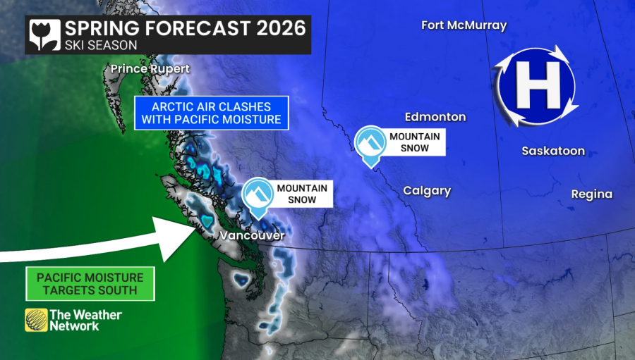
For much of B.C., temperatures are forecast to trend near to below seasonal norms through the first half of spring, accompanied by periods of above-normal precipitation. In the mountains, additional snowfall and cooler conditions could allow the snowpack to continue building into April.
.png)
That may offer short-term benefits for ski areas, particularly along the South Coast, where winter conditions were relatively mild. A return to more typical late-winter patterns could help salvage the end of what has been a disappointing season in some regions.
But the deeper snowpack also carries risks. If temperatures flip abruptly warmer later in spring — a scenario Gillham said is possible in May — rapid snowmelt combined with rainfall could increase the risk of flooding in parts of the province.
“At this point, there are no specific red flags for any one region,” Gillham said in the forecast. “But it does heighten vigilance as we watch how the spring unfolds.”
The outlook suggests Western Canada is the most likely region to see an abrupt transition to warmer and drier conditions later in the season. Whether that warmth spreads east remains uncertain.
That potential late-spring shift raises concerns about wildfire risk, particularly if dry conditions take hold after a prolonged cool and damp start. Gillham noted that the forecast bears some resemblance to 2023 — the beginning of Canada’s worst wildfire season on record — though he cautioned that this does not mean a repeat is inevitable.
Canada is emerging from a winter influenced by disruptions to the polar vortex and the fading effects of La Niña, a Pacific climate pattern that typically brings cooler and stormier conditions to parts of the country. With La Niña now weakening, forecasters are looking to historical comparisons for guidance, but acknowledge that May remains highly uncertain.
“I readily admit that May could blow up that map,” Gillham said, referring to projected temperature and precipitation anomalies.
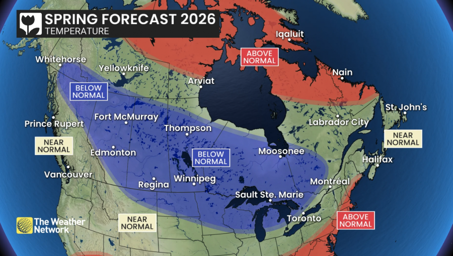
Elsewhere in Canada, the Prairies are also expected to see a colder-than-normal start to spring with an active storm track, while Ontario and Quebec may experience a sluggish departure from winter, punctuated by brief warm spells that lack staying power. Atlantic Canada appears most likely to see near-normal seasonal conditions, while much of Northern Canada is forecast to trend warmer than normal.
The forecast also unfolds against a longer-term warming backdrop. Average spring temperatures in Canada are now roughly 2.1 C warmer than they were in the mid-20th century, and the growing season begins several days earlier on average.
Still, forecasters say British Columbians should be prepared for a drawn-out and at times volatile spring, with conditions that could pivot quickly from cool and wet to hot and dry as the season progresses.


